IMAGES TAKEN NEAR TO
Station Road, DERBY, DE73 8HJ
Introduction
This page details the photographs taken nearby to Station Road, DE73 8HJ by members of the Geograph project.
The Geograph project started in 2005 with the aim of publishing, organising and preserving representative images for every square kilometre of Great Britain, Ireland and the Isle of Man.

There are currently over 7.5m images from over14,400 individuals and you can help contribute to the project by visiting https://www.geograph.org.uk
Image Map
Images are licensed for reuse under creativecommons.org/licenses/by-sa/2.0
Notes
- Clicking on the map will re-center to the selected point.
- The higher the marker number, the further away the image location is from the centre of the postcode.
Image Listing (36 Images Found)
Images are licensed for reuse under creativecommons.org/licenses/by-sa/2.0
Image
Details
Distance
1
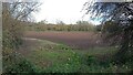
Farmland on the east bank of Carr Brook
About 40 metres above sea level.
Image: © Christine Johnstone
Taken: 4 Nov 2020
0.04 miles
2
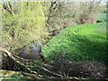
Carr Brook at Melbourne Station
Carr Brook emerges from a culvert under the former Melbourne Railway Station.
Image: © Ian Calderwood
Taken: 1 Apr 2012
0.05 miles
3
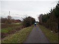
Cyclist on the Cloud Trail
Pictured here close to Melbourne Road to the east of the village.
Image: © Jonathan Clitheroe
Taken: 28 Feb 2015
0.05 miles
4
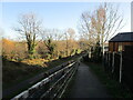
'Maintain social distance' by the site of Melbourne station
On the Cloud Trail / NCN route 6 - the former Derby - Ashby railway line.
Image: © Christine Johnstone
Taken: 4 Nov 2020
0.07 miles
5
The site of Melbourne Station
The station opened in 1868 and closed to passengers in 1930, During the Second World War the line was used by the War Department. Freight services eventually ceased in 1980. The course of the railway is now part of the Cloud Trail.
Image: © Jonathan Thacker
Taken: 5 Jan 2022
0.08 miles
6
The site of Melbourne railway station
The site of Melbourne railway station, now covered by light industrial units, taken from the bridge carrying the Melbourne - Isley Walton road. The trackbed of the line from Derby to Ashby-de-la-Zouch was converted to the Cloud Trail after the branch finally closed in 1982.
Image: © Richard Green
Taken: 4 Mar 2013
0.08 miles
8
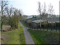
Cycle trail heading south
On the former Derby to Ashby Railway.
Image: © JThomas
Taken: 12 Jul 2013
0.09 miles
9
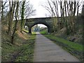
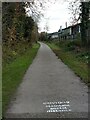
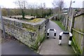
Melbourne station road bridge
The road bridge at the north end of the former Melbourne railway station site. Several attractive 3 arched stone bridges were built over the branch line from Derby to Ashby-de-la-Zouch, which finally closed in 1982 and was converted to the Cloud Trail.
Image: © Richard Green
Taken: 4 Mar 2013
0.10 miles
10
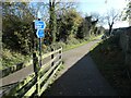
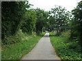
Signpost on the Cloud Trail, Melbourne
The former Derby - Ashby railway line is part of the national cycle route 6 here.
Image: © Christine Johnstone
Taken: 4 Nov 2020
0.11 miles