IMAGES TAKEN NEAR TO
Derby Hills, DERBY, DE73 7LL
Introduction
This page details the photographs taken nearby to Derby Hills, DE73 7LL by members of the Geograph project.
The Geograph project started in 2005 with the aim of publishing, organising and preserving representative images for every square kilometre of Great Britain, Ireland and the Isle of Man.

There are currently over 7.5m images from over14,400 individuals and you can help contribute to the project by visiting https://www.geograph.org.uk
Image Map
Images are licensed for reuse under creativecommons.org/licenses/by-sa/2.0
Notes
- Clicking on the map will re-center to the selected point.
- The higher the marker number, the further away the image location is from the centre of the postcode.
Image Listing (8 Images Found)
Images are licensed for reuse under creativecommons.org/licenses/by-sa/2.0
Image
Details
Distance
1
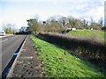
Road and reservoir, Derby Hills
Taken while looking for Ordnance Survey "furniture" buried in the verge.
Image: © Richard Webb
Taken: 6 Jan 2004
0.09 miles
2
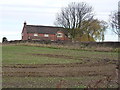
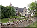
Hemsley Barn Cottage
A fine house just north of Melbourne Lane, Ticknall.
Image: © Richard Law
Taken: 4 Dec 2013
0.15 miles
4
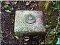
OS Fundamental Benchmark - Ticknall
Fundamental Benchmark in the verge on the south side of Melbourne Lane, east of Ticknall. It looks like this one is normally underground, but in this case it's been excavated by a keen benchmark bagger. The tag says it's at 374.32 feet above Ordnance Datum.
Image: © Richard Law
Taken: 4 Dec 2013
0.18 miles
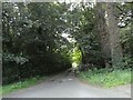
5
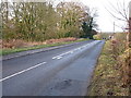
Melbourne Lane into Ticknall
A general view of the road, and the location of the Image, which is down the verge more or less opposite the first chevron sign
Image: © Richard Law
Taken: 4 Dec 2013
0.20 miles
6
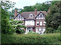
Broadstone
A large house on Broadstone Lane
Image: © Graham Hogg
Taken: 9 May 2017
0.22 miles
7
Broadstone End
Also known as Broadstone Lane End
Image: © Ian Calderwood
Taken: 21 Jun 2013
0.24 miles
8
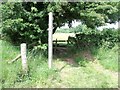
Signpost and Stile on the Reservoirs Walk
The Reservoirs Walk is a circular walk linking Staunton Harold Reservoir with Foremark Reservoir. In doing so, it passes through Calke Park and The National Forest.
Image: © Ian Calderwood
Taken: 21 Jun 2013
0.24 miles