IMAGES TAKEN NEAR TO
Trent Side, DERBY, DE73 7GU
Introduction
This page details the photographs taken nearby to Trent Side, DE73 7GU by members of the Geograph project.
The Geograph project started in 2005 with the aim of publishing, organising and preserving representative images for every square kilometre of Great Britain, Ireland and the Isle of Man.

There are currently over 7.5m images from over14,400 individuals and you can help contribute to the project by visiting https://www.geograph.org.uk
Image Map
Images are licensed for reuse under creativecommons.org/licenses/by-sa/2.0
Notes
- Clicking on the map will re-center to the selected point.
- The higher the marker number, the further away the image location is from the centre of the postcode.
Image Listing (121 Images Found)
Images are licensed for reuse under creativecommons.org/licenses/by-sa/2.0
Image
Details
Distance
1
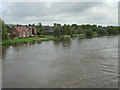
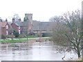
High water
The River Trent at Swarkestone showing the effects of the recent heavy rain, but still just within its banks.
Image: © Alan Murray-Rust
Taken: 7 Sep 2008
0.02 miles
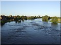
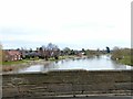
2
River Trent downstream of Swarkestone Bridge
Image: © John M
Taken: 31 May 2010
0.02 miles
3
The Trent in Flood at Swarkestone
June 2007 was unseasonably wet, causing severe problems in parts of the Midlands and Northern England. South Derbyshire was not so badly affected but the Trent flooded, as it is liable to do. The name Trent is thought to mean "trespasser", meaning "river liable to flood".
Image: © Ian Calderwood
Taken: 27 Jun 2007
0.02 miles
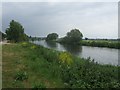
4
Path Alongside the Trent at Swarkestone
Image: © David Dixon
Taken: 20 Sep 2014
0.03 miles
6
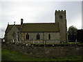
Swarkestone Parish church
The church at Swarkestone
Image: © Peter Shone
Taken: 29 Sep 2005
0.04 miles
8
River Trent at Swarkestone Bridge
Looking east.
There is a bench mark http://www.geograph.org.uk/photo/5701634 on the parapet.
Image: © Alan Murray-Rust
Taken: 6 Mar 2018
0.06 miles
9
The Reading Room, Swarkestone
An early provision of educational facilities for the village, dating from the early 19th century, with later extension to the rear, now a house. Listed Grade II.
Image: © Alan Murray-Rust
Taken: 6 Mar 2018
0.06 miles
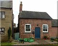
10

The Reading Room, Swarkestone
Grade II listed, this tiny property is now a house with extensions at the side and rear
Image: © Eirian Evans
Taken: 4 Jul 2010
0.06 miles