IMAGES TAKEN NEAR TO
Ferrers Drive, DERBY, DE73 6XR
Introduction
This page details the photographs taken nearby to Ferrers Drive, DE73 6XR by members of the Geograph project.
The Geograph project started in 2005 with the aim of publishing, organising and preserving representative images for every square kilometre of Great Britain, Ireland and the Isle of Man.

There are currently over 7.5m images from over14,400 individuals and you can help contribute to the project by visiting https://www.geograph.org.uk
Image Map
Images are licensed for reuse under creativecommons.org/licenses/by-sa/2.0
Notes
- Clicking on the map will re-center to the selected point.
- The higher the marker number, the further away the image location is from the centre of the postcode.
Image Listing (6 Images Found)
Images are licensed for reuse under creativecommons.org/licenses/by-sa/2.0
Image
Details
Distance
1
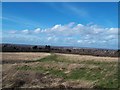
View over Derby from Chellaston Hill
This is one of the best vantage points for a panoramic view of the city.
Image: © Jonathan Clitheroe
Taken: 22 Feb 2014
0.04 miles
2
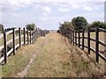
Bridleway over a ridge and furrow field
The bridleway from Chellaston to Weston was diverted from its original course over a medieval ridge and furrow field.
Image: © Ian Calderwood
Taken: 5 Aug 2011
0.11 miles
4
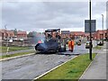
Finishing off at Chellaston Fields
Early in 2023, after the last houses were finished, it was time to complete the landscaping and surface the remaining roads and pavements.
Image: © Ian Calderwood
Taken: 16 Mar 2023
0.18 miles
5
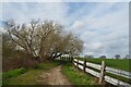
Old willow
Beside the bridleway between Chellaston and Weston-on-Trent.
The crash barrier fence seems a little over the top!
Image: © David Lally
Taken: 22 Mar 2023
0.21 miles
6
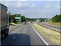
Westbound A50 Approaching 'Bonnie Prince Roundabout
The A50 approaching Junction 3, known locally as 'Bonnie Prince Roundabout'.
Image: © David Dixon
Taken: 8 Aug 2014
0.25 miles