IMAGES TAKEN NEAR TO
Carradale Grove, DERBY, DE73 5WZ
Introduction
This page details the photographs taken nearby to Carradale Grove, DE73 5WZ by members of the Geograph project.
The Geograph project started in 2005 with the aim of publishing, organising and preserving representative images for every square kilometre of Great Britain, Ireland and the Isle of Man.

There are currently over 7.5m images from over14,400 individuals and you can help contribute to the project by visiting https://www.geograph.org.uk
Image Map
Images are licensed for reuse under creativecommons.org/licenses/by-sa/2.0
Notes
- Clicking on the map will re-center to the selected point.
- The higher the marker number, the further away the image location is from the centre of the postcode.
Image Listing (17 Images Found)
Images are licensed for reuse under creativecommons.org/licenses/by-sa/2.0
Image
Details
Distance
1

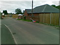
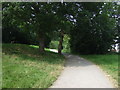
Chellaston, Royal Glen Park
Chellaston is a suburb of the City of Derby, which is in the East Midlands of England. It is on a natural hill, and has recently expanded due to several new housing estates. Royal Glen Park is one such housing development.
Lying approximately 5 miles south of Derby city centre, Chellaston is the southernmost part of the city.
Image: © David Dixon
Taken: 15 Sep 2015
0.08 miles
3
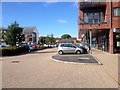
Royal Glen Park, Chellaston
Car park at the small, neighbourhood shopping precinct.
Image: © David Dixon
Taken: 15 Sep 2015
0.11 miles
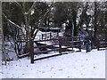
4
Crossing on Infinity Park Way, Chellaston
On the line of the former Derby Canal. Provided for users of the public footpath that follows the route of the canal towpath.
Image: © Christine Johnstone
Taken: 16 Feb 2023
0.17 miles
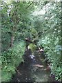
5
Bridge over Cuttle Brook
This bridge carries the footpath and cycle track that follows the route of the old Derby Canal. The canal and its towing path used to cross by an aqueduct but this was removed after the canal closed in 1964.
Image: © Ian Calderwood
Taken: 5 Feb 2012
0.18 miles
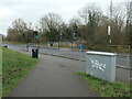
7
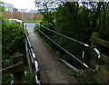
Footbridge across Cuttle Brook
Next to Infinity Park Way at Chellaston, the southern most suburb of Derby. The footbridge carries the Cloud Way and National Cycle Route 6 across the brook.
Image: © Mat Fascione
Taken: 4 Jun 2017
0.18 miles
8
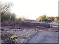
Construction of the temporary Derby Canal crossing for the T12 road development
Begun in late 2014, the temporary crossing is needed to provide access to the Infinity Park site. This will include the T12 link road, which will run through the site between Holmleigh Way and Wilmore Road and will have a permanent bridge over the canal here.
Image: © Ian Calderwood
Taken: 19 Dec 2014
0.18 miles
10
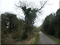
Ivy-covered tree, Chellaston
Growing in the bed of the former Derby Canal. The Derby Canal opened in 1796 and was abandoned in 1964. The Derby and Sandiacre Canal Trust are working to reopen it. The Cloud Trail and NCN route 6 follow the former towpath, which is also a public footpath.
Image: © Christine Johnstone
Taken: 16 Feb 2023
0.19 miles