IMAGES TAKEN NEAR TO
Lady Mantle Close, DERBY, DE73 5PY
Introduction
This page details the photographs taken nearby to Lady Mantle Close, DE73 5PY by members of the Geograph project.
The Geograph project started in 2005 with the aim of publishing, organising and preserving representative images for every square kilometre of Great Britain, Ireland and the Isle of Man.

There are currently over 7.5m images from over14,400 individuals and you can help contribute to the project by visiting https://www.geograph.org.uk
Image Map
Images are licensed for reuse under creativecommons.org/licenses/by-sa/2.0
Notes
- Clicking on the map will re-center to the selected point.
- The higher the marker number, the further away the image location is from the centre of the postcode.
Image Listing (20 Images Found)
Images are licensed for reuse under creativecommons.org/licenses/by-sa/2.0
Image
Details
Distance
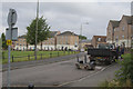
1
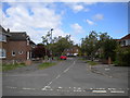
South end of Springfield Road, Chellaston
Off Sinfin Moor Lane.
Image: © Richard Vince
Taken: 4 May 2019
0.11 miles
2
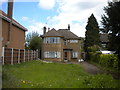
House in a timewarp, Sinfin Moor Lane, Chellaston
What appears to be a 1930s vintage detached dwelling, still fitted with curved glazing in the corners of the bay windows.
Image: © Richard Vince
Taken: 4 May 2019
0.11 miles
3
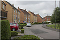
Cordelia Way
This circle of houses around a green island is just off Sinfin Moor Lane. The housing must be less than 25 years old because that long ago I was taking my eldest daughter to a horse riding stable where this block of houses is. The price of progress I suppose.
Image: © Malcolm Neal
Taken: 30 Jun 2017
0.14 miles
4
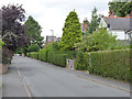
Sinfin Moor Lane
The earliest housing on this former country lane dates from around the beginning of the 20th century.
Image: © Alan Murray-Rust
Taken: 14 Aug 2013
0.14 miles
5
Cordelia Way
These houses are less than 25 years old and on the site of a horse riding school my daughters used to frequent.
Image: © Malcolm Neal
Taken: 30 Jun 2017
0.16 miles
6
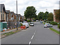
Parkway, Chellaston
Main access road to a large housing development on the west side of Chellaston.
Image: © Alan Murray-Rust
Taken: 14 Aug 2013
0.17 miles
7
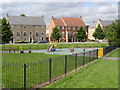
Montague Way, Chellaston
An attractive circular green with recreational area has been created here.
Image: © Alan Murray-Rust
Taken: 14 Aug 2013
0.17 miles
8
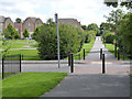
Sinfin Moor Lane
The former rural byway is now a footpath through the middle of the housing estate.
Image: © Alan Murray-Rust
Taken: 14 Aug 2013
0.18 miles
9
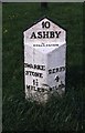
Old Milepost by the A514, Derby Road, Chellaston
Cast iron post by the A514, in parish of DERBY (DERBY District), Derby Road, Chellaston, opposite No. 74, North of junction with Maple Drive mini roundabout, on wide well cut grass verge (with daffodils in it) between main road and cul de sac for houses, on East side of road. Paragon Recast, erected by the County Council in the 20th century.
Inscription reads:-
: SWARKE- / STONE / 1½ / MILES : : 10 / ASHBY / Chellaston : : DERBY / 4 / MILES : : PATTERN SUPPLIED / BY / PARAGON PATTERNS / B.O.T. :
Milestone Society National ID: DE_DEAY04.
Image: © A Rosevear & J Higgins
Taken: 1 Apr 2001
0.18 miles
10
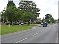
Derby Road, Chellaston
This is the old main road between Derby and Ashby-de-la-Zouch. Note the old cast iron milepost http://www.geograph.org.uk/photo/3640809 on the left.
Image: © Alan Murray-Rust
Taken: 14 Aug 2013
0.18 miles