IMAGES TAKEN NEAR TO
Queensgate Drive, DERBY, DE73 5NW
Introduction
This page details the photographs taken nearby to Queensgate Drive, DE73 5NW by members of the Geograph project.
The Geograph project started in 2005 with the aim of publishing, organising and preserving representative images for every square kilometre of Great Britain, Ireland and the Isle of Man.

There are currently over 7.5m images from over14,400 individuals and you can help contribute to the project by visiting https://www.geograph.org.uk
Image Map
Images are licensed for reuse under creativecommons.org/licenses/by-sa/2.0
Notes
- Clicking on the map will re-center to the selected point.
- The higher the marker number, the further away the image location is from the centre of the postcode.
Image Listing (20 Images Found)
Images are licensed for reuse under creativecommons.org/licenses/by-sa/2.0
Image
Details
Distance
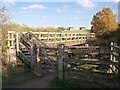
1
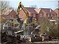
Demolishing the old farm bridge over Cuttle Brook
The redundant former farm bridge over Cuttle Brook was removed as part of the development of the site for housing.
Image: © Ian Calderwood
Taken: 25 Feb 2021
0.09 miles
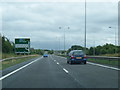
2
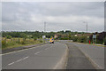
Infinity Park Way
Here the road is a dual carriageway but after the island visible to the left it becomes a single carriageway.
Image: © Malcolm Neal
Taken: 30 Jun 2017
0.11 miles
3
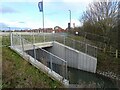
Eagle Drive crossing Cuttle Brook
Since Image was taken, the fields beyond have been developed for housing and the footbridge pictured has been removed. The footpath now stops at Eagle Drive, a new road built to serve the new houses.
Image: © Ian Calderwood
Taken: 20 Dec 2020
0.12 miles
4
New children's play park
With construction work in the area complete, one of the last touches was to add a children's play park to the green space off Eagle Drive.
Image: © Ian Calderwood
Taken: 7 Mar 2023
0.12 miles
5
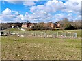
Footbridge over Cuttle Brook
This bridge has carried the footpath from Chellaston to Swarkestone Lock over Cuttle Brook since it was diverted here, when the Derby Southern Bypass (A50) was built in the 1990s. The previous crossing was about 100 metres to the South.
Image: © Ian Calderwood
Taken: 28 Oct 2011
0.14 miles
7
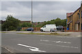
Infinity Park Way
I assume the road has this name as it does seem to stretch for miles as it meanders towards the major Derby employer Rolls Royce and their test beds and other parts of the works.
Image: © Malcolm Neal
Taken: 30 Jun 2017
0.16 miles
8
The Derby Canal, near Chellaston's Eagle Drive
The Derby Canal opened in 1796 and was abandoned in 1964. The Derby and Sandiacre Canal Trust are working to reopen it. The Cloud Trail and NCN route 6 follow the former towpath, which is also a public footpath.
Image: © Christine Johnstone
Taken: 16 Feb 2023
0.17 miles
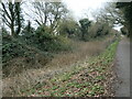
9
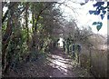
Snicket at the Southern Edge of Chellaston
Image: © Jonathan Clitheroe
Taken: 22 Feb 2014
0.17 miles
10
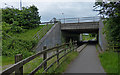
National Cycle Route 6 at Chellaston
Following the route of the former Derby Canal. The cycle route is about to pass under the A50 near Chellaston, the southern most suburb of Derby.
Image: © Mat Fascione
Taken: 4 Jun 2017
0.18 miles