
IMAGES TAKEN NEAR TO
Tudor Court, DERBY, DE72 3YQ
Introduction
This page details the photographs taken nearby to Tudor Court, DE72 3YQ by members of the Geograph project.
The Geograph project started in 2005 with the aim of publishing, organising and preserving representative images for every square kilometre of Great Britain, Ireland and the Isle of Man.

There are currently over 7.5m images from over14,400 individuals and you can help contribute to the project by visiting https://www.geograph.org.uk
Image Map
Images are licensed for reuse under creativecommons.org/licenses/by-sa/2.0
Notes
- Clicking on the map will re-center to the selected point.
- The higher the marker number, the further away the image location is from the centre of the postcode.
Image Listing (7 Images Found)
Images are licensed for reuse under creativecommons.org/licenses/by-sa/2.0
Image
Details
Distance
1

Entrance to Coppice Park
The housing mentioned in Image has long-since been built and is called Coppice Park.
Image: © David Lally
Taken: 24 Jan 2009
0.08 miles
2

Former Hotel Entrance near Draycott, Derbyshire
This hotel closed last year and is now being redeveloped as housing. As part of the development the builder has put up these fences to protect the trees near the entrance of the hotel from damage.
Image: © Peter Shone
Taken: 13 Oct 2005
0.08 miles
3

Gypsy Lane near Borrowash
Plus some rather sad low-level fly-tip debris.
Image: © Jonathan Clitheroe
Taken: 29 Dec 2013
0.13 miles


6

Fields behind Draycott Manor
The flat bottom valley fields of the River Derwent are crossed by a Roman Road, on which sits Draycott Manor. The manor can just be made out in the left of the image.
Image: © Peter Shone
Taken: 13 Oct 2005
0.23 miles
7
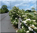
Elderflowers along Derby Road in Draycott
Image: © Mat Fascione
Taken: 4 Jun 2017
0.24 miles