
IMAGES TAKEN NEAR TO
Aston-on-Trent, DERBY, DE72 2DZ
Introduction
This page details the photographs taken nearby to DE72 2DZ by members of the Geograph project.
The Geograph project started in 2005 with the aim of publishing, organising and preserving representative images for every square kilometre of Great Britain, Ireland and the Isle of Man.

There are currently over 7.5m images from over14,400 individuals and you can help contribute to the project by visiting https://www.geograph.org.uk
Image Map
Images are licensed for reuse under creativecommons.org/licenses/by-sa/2.0
Notes
- Clicking on the map will re-center to the selected point.
- The higher the marker number, the further away the image location is from the centre of the postcode.
Image Listing (39 Images Found)
Images are licensed for reuse under creativecommons.org/licenses/by-sa/2.0
Image
Details
Distance
2
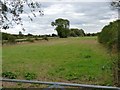
Charity land at Hanger Bank, Aston-on-Trent
This field is the property of the Elvaston United Charities. This charity dates back to William Piggin, whose family originated in the Elvaston area: he went to London and became prosperous. At his death in 1621 he left money to buy property and land, the benefit of which was to go to the poor people of the ancient villages of Elvaston, Ambaston and Thulston.
Image: © Richard Green
Taken: 21 Aug 2011
0.14 miles
4

The Malt Shovel
The building was originally a farm but was converted to a pub in 1907.
Image: © Ian Calderwood
Taken: 27 Jul 2010
0.15 miles
5
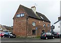
Yeoman House, 16 The Green, Aston-on-Trent
Late 17th century former farmhouse, now converted to offices. Dated 1690 in the stone lozenge between the first floor windows. Listed Grade II.
The local Conservation Area Appraisal is uncomplimentary about the use of dark mortar in the area of the diaper brickwork, which rather destroys the delicacy of the patterning as it should appear (compare with http://www.geograph.org.uk/photo/5681106 ).
Image: © Alan Murray-Rust
Taken: 11 Feb 2018
0.15 miles
6
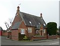
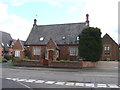
Former village school, Derby Road, Aston-on-Trent
Built in 1844 in Gothic Revival style with diaper brickwork and cast-iron latticed windows. Now a private house.
Image: © Alan Murray-Rust
Taken: 11 Feb 2018
0.15 miles
7
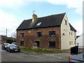
Yeoman House, 16 The Green, Aston-on-Trent
Late 17th century former farmhouse, now converted to offices. Dated 1690 in the stone lozenge between the first floor windows. Listed Grade II. The local Conservation Area Appraisal is uncomplimentary about the use of dark mortar in the area of the diaper brickwork, which rather destroys the delicacy of the patterning as it should appear (compare with http://www.geograph.org.uk/photo/5681106 ).
Image: © Alan Murray-Rust
Taken: 11 Feb 2018
0.15 miles
8

Datestone, Yeoman House, 16 The Green, Aston-on-Trent
This is considered by the Local History Group to relate to a Christopher Wright. See http://www.geograph.org.uk/photo/5681098 for location.
Image: © Alan Murray-Rust
Taken: 11 Feb 2018
0.15 miles
10
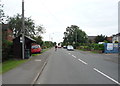
Bus stop and shelter on Derby Road, Aston-on-Trent
Looking north.
Image: © JThomas
Taken: 21 Jul 2016
0.16 miles