IMAGES TAKEN NEAR TO
Old Plough Close, DERBY, DE72 2BS
Introduction
This page details the photographs taken nearby to Old Plough Close, DE72 2BS by members of the Geograph project.
The Geograph project started in 2005 with the aim of publishing, organising and preserving representative images for every square kilometre of Great Britain, Ireland and the Isle of Man.

There are currently over 7.5m images from over14,400 individuals and you can help contribute to the project by visiting https://www.geograph.org.uk
Image Map
Images are licensed for reuse under creativecommons.org/licenses/by-sa/2.0
Notes
- Clicking on the map will re-center to the selected point.
- The higher the marker number, the further away the image location is from the centre of the postcode.
Image Listing (45 Images Found)
Images are licensed for reuse under creativecommons.org/licenses/by-sa/2.0
Image
Details
Distance
1
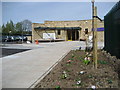
Site of the Old Plough Inn
The Plough was a feature of the centre of Weston on Trent from the early 1800s. After closing in 2009, it was taken over by an investment company and, despite protests from local residents, subsequently demolished.
Image: © Ian Calderwood
Taken: 31 Jul 2010
0.00 miles
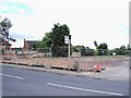
2
Weston on Trent Scarecrow Trail 2015
Along Weston Road in Weston upon Trent.
Image: © Mat Fascione
Taken: 21 Jun 2015
0.03 miles
3
The Plough Inn
The Plough Inn, Weston on Trent. Refurbished in 2006.
Image: © Phil Myott
Taken: 1 Dec 2006
0.03 miles
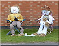
4
Weston on Trent Scarecrow Trail 2015
On the corner of Weston Road and the Pastures in Weston upon Trent.
Image: © Mat Fascione
Taken: 21 Jun 2015
0.06 miles
5
The New Weston School
The new school was officially opened on Saturday 21st of April.
Image: © Kingfishers
Taken: 17 Apr 2007
0.08 miles
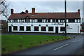
6
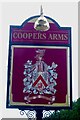
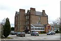
The sign of the Coopers Arms
The pub is housed in a 17th century grade II* listed hall : Image
Image: © David Lally
Taken: 18 Mar 2023
0.14 miles
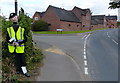
7
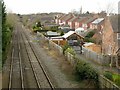
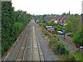
Looking west from Kings Mills Lane
The houses on the right occupy the site of the goods yard of Weston station. This closed in 1967, the passenger service having been withdrawn as early as 1930. The line still carries long distance freight, avoiding Derby.
Image: © Alan Murray-Rust
Taken: 6 Mar 2018
0.15 miles
8
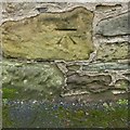
Bench mark, 35 Main Street, Weston-on-Trent
See http://www.geograph.org.uk/photo/5700659 for location.
Image: © Alan Murray-Rust
Taken: 6 Mar 2018
0.15 miles
9
Railway at Weston-on-Trent in Derbyshire
Looking west from the bridge over King's Mill Lane. This railway is used for freight only currently.
The railway opened from Trent to Weston in 1869, and through to Stenson Junction by 1873. Passenger services ceased in 1930.
2018 image: Image]
Image: © Roger Kidd
Taken: 27 Aug 2013
0.16 miles
10
Weston Hall, Weston on Trent
A large country house, probably started in around 1633 by the Roper family, but remaining incomplete when the family fortunes went downhill in the Civil War. Now a pub restaurant, also catering for functions. Listed Grade II*.
Image: © Alan Murray-Rust
Taken: 6 Mar 2018
0.16 miles