IMAGES TAKEN NEAR TO
Rodsley Lane, ASHBOURNE, DE6 3DD
Introduction
This page details the photographs taken nearby to Rodsley Lane, DE6 3DD by members of the Geograph project.
The Geograph project started in 2005 with the aim of publishing, organising and preserving representative images for every square kilometre of Great Britain, Ireland and the Isle of Man.

There are currently over 7.5m images from over14,400 individuals and you can help contribute to the project by visiting https://www.geograph.org.uk
Image Map (10 Images)


Getting Data...Please wait
Leaflet Map data © OpenStreetMap
Images are licensed for reuse under creativecommons.org/licenses/by-sa/2.0
Notes
- Clicking on the map will re-center to the selected point.
- The higher the marker number, the further away the image location is from the centre of the postcode.
Image Listing (10 Images Found)
Images are licensed for reuse under creativecommons.org/licenses/by-sa/2.0
Image
Details
Distance
1
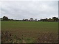
Park Style Farm and Adjoining Fields
Viewed from one of a pair of footpaths leading to Longford Park.
Image: © Jonathan Clitheroe
Taken: 25 Oct 2014
0.04 miles
2
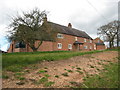
Park Style Farm
This is the main farmhouse seen from the road to Rodsley, and it, along with the outbuildings just visible beyond has been modernised and converted into a small community of dwellings.
Image: © David Stowell
Taken: 7 Apr 2009
0.04 miles
3
Park Style Farm
Taken from the path opposite the farm.
Image: © John Poyser
Taken: 22 Jan 2007
0.07 miles
4
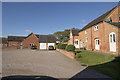
Park Style Farm new houses
These houses are close to Park Style Farm and are essentially barn conversions that happened a few years ago ( I think about 2007 or perhaps a little earlier ).
Image: © Malcolm Neal
Taken: 27 Oct 2017
0.08 miles
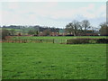
5
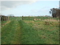
Spot the stile
Walking this path involved jumping the fence as no stile was evident.
Image: © John Poyser
Taken: 22 Jan 2007
0.08 miles
6
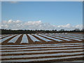
Polytunnels at Park Style Farm
The polythene sheets provide a decidedly non-agricultural looking lines in a field beside the lane to Rodsley.
Image: © David Stowell
Taken: 7 Apr 2009
0.12 miles
7

Rodsley Lane
Carr Wood on the right.
Image: © J.Hannan-Briggs
Taken: 5 Dec 2013
0.18 miles
8
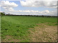
Field and Clouds
At the end of this field lies the village of Rodsley.
Image: © Michael Patterson
Taken: 27 Apr 2006
0.21 miles
9
Copse near the path
Copse near to the path back to Park Style Farm
Image: © John Poyser
Taken: 22 Jan 2007
0.22 miles
10

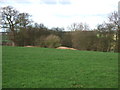
Carr Wood
Looking towards Carr Wood from the footpath (across a recently ploughed field!) between Longford Hall and Park Style Farm.
Image: © David Stowell
Taken: 7 Apr 2009
0.23 miles