IMAGES TAKEN NEAR TO
Derby Lane, ASHBOURNE, DE6 3AT
Introduction
This page details the photographs taken nearby to Derby Lane, DE6 3AT by members of the Geograph project.
The Geograph project started in 2005 with the aim of publishing, organising and preserving representative images for every square kilometre of Great Britain, Ireland and the Isle of Man.

There are currently over 7.5m images from over14,400 individuals and you can help contribute to the project by visiting https://www.geograph.org.uk
Image Map
Images are licensed for reuse under creativecommons.org/licenses/by-sa/2.0
Notes
- Clicking on the map will re-center to the selected point.
- The higher the marker number, the further away the image location is from the centre of the postcode.
Image Listing (78 Images Found)
Images are licensed for reuse under creativecommons.org/licenses/by-sa/2.0
Image
Details
Distance

3
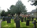
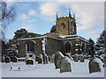
Gravestones, St Michael's church, Shirley
Image: © David Smith
Taken: 27 Apr 2022
0.06 miles
4
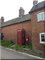
Former phone box, Derby Lane, Shirley
The phone box is now a book-swap library
Image: © David Smith
Taken: 27 Apr 2022
0.06 miles
6
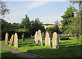
Evening sunlight in Shirley churchyard
Looking north-east early on a July evening.
Image: © John Sutton
Taken: 21 Jul 2014
0.06 miles
9
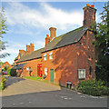
Shirley: the corner of Derby Lane
Summer-evening sunlight on red brick in the centre of the village, more or less opposite the Saracen's Head.
Image: © John Sutton
Taken: 21 Jul 2014
0.07 miles