IMAGES TAKEN NEAR TO
Hollies Lane, ASHBOURNE, DE6 2EW
Introduction
This page details the photographs taken nearby to Hollies Lane, DE6 2EW by members of the Geograph project.
The Geograph project started in 2005 with the aim of publishing, organising and preserving representative images for every square kilometre of Great Britain, Ireland and the Isle of Man.

There are currently over 7.5m images from over14,400 individuals and you can help contribute to the project by visiting https://www.geograph.org.uk
Image Map
Images are licensed for reuse under creativecommons.org/licenses/by-sa/2.0
Notes
- Clicking on the map will re-center to the selected point.
- The higher the marker number, the further away the image location is from the centre of the postcode.
Image Listing (9 Images Found)
Images are licensed for reuse under creativecommons.org/licenses/by-sa/2.0
Image
Details
Distance
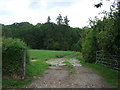
1
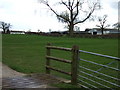
Sandhills Farm
A large farm set back from the road.
Image: © John Poyser
Taken: 14 Mar 2007
0.05 miles
2
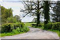
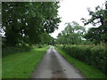
Driveway to Sandhills Farm off Hollies Lane
Image: © Mick Malpass
Taken: 13 May 2012
0.14 miles
3
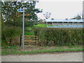
Footpath and Dog Kennels
The kennels were part of the local estate, now unused.
Image: © John Poyser
Taken: 14 Mar 2007
0.15 miles
4
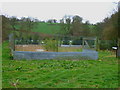
Pheasant Rearing Pens
Pens used to rear pheasants ready for the shooting season on the local estate.
Image: © John Poyser
Taken: 14 Mar 2007
0.15 miles
5
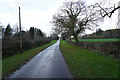
Hollies Lane
The tarmac surface of Hollies Lane is far better than many of the minor roads around here.
Image: © Malcolm Neal
Taken: 4 Dec 2021
0.17 miles
6
Hollies Lane
Heading east towards the A515.
Image: © JThomas
Taken: 20 Jun 2015
0.17 miles
7
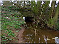
Cubley Brook
The Hollies Lane road bridge over Cubley Brook near Sandhills Farm.
Image: © John Poyser
Taken: 14 Mar 2007
0.18 miles
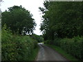
8
Farm track off Hollies Lane
Looking north towards Accession Wood.
Image: © JThomas
Taken: 20 Jun 2015
0.21 miles
9
Hollies Lane
Heading east towards the A515.
Image: © JThomas
Taken: 20 Jun 2015
0.22 miles