IMAGES TAKEN NEAR TO
Brookside Meadows, ASHBOURNE, DE6 1RQ
Introduction
This page details the photographs taken nearby to Brookside Meadows, DE6 1RQ by members of the Geograph project.
The Geograph project started in 2005 with the aim of publishing, organising and preserving representative images for every square kilometre of Great Britain, Ireland and the Isle of Man.

There are currently over 7.5m images from over14,400 individuals and you can help contribute to the project by visiting https://www.geograph.org.uk
Image Map
Images are licensed for reuse under creativecommons.org/licenses/by-sa/2.0
Notes
- Clicking on the map will re-center to the selected point.
- The higher the marker number, the further away the image location is from the centre of the postcode.
Image Listing (5 Images Found)
Images are licensed for reuse under creativecommons.org/licenses/by-sa/2.0
Image
Details
Distance
1
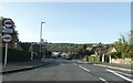
Park Avenue, Ashbourne
Access road into large housing estate on east side of Ashbourne
Image: © David Smith
Taken: 5 Sep 2023
0.10 miles
2
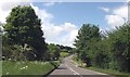
Belper road entering Ashbourne
East of Park Avenue
Image: © John Firth
Taken: 15 Jun 2013
0.11 miles
3
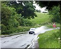
Causing a splash
A rainy day on the A517 east of Ashbourne
Image: © Graham Hogg
Taken: 9 Jun 2014
0.13 miles
5
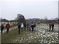
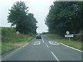
Royal Shrovetide - Fields behind Park Avenue
All of these fields can come into play during the game.
Image: © John M
Taken: 12 Feb 2013
0.18 miles