IMAGES TAKEN NEAR TO
Standlow Lane, ASHBOURNE, DE6 1QZ
Introduction
This page details the photographs taken nearby to Standlow Lane, DE6 1QZ by members of the Geograph project.
The Geograph project started in 2005 with the aim of publishing, organising and preserving representative images for every square kilometre of Great Britain, Ireland and the Isle of Man.

There are currently over 7.5m images from over14,400 individuals and you can help contribute to the project by visiting https://www.geograph.org.uk
Image Map
Images are licensed for reuse under creativecommons.org/licenses/by-sa/2.0
Notes
- Clicking on the map will re-center to the selected point.
- The higher the marker number, the further away the image location is from the centre of the postcode.
Image Listing (8 Images Found)
Images are licensed for reuse under creativecommons.org/licenses/by-sa/2.0
Image
Details
Distance
1
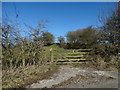
On Standlow Lane, Kniveton
View to the old lime kiln partly hidden by the bushes beyond the gate.
Image: © Neil Theasby
Taken: 7 Mar 2016
0.06 miles
2
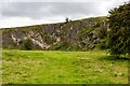
Quarry
Disused quarry alongside Standlow Lane.
Image: © Peter McDermott
Taken: 28 Aug 2023
0.10 miles
4
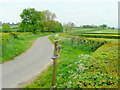
Longrose Lane
Looking west past a birdtable on an isolated corner of a country lane.
Image: © Jonathan Billinger
Taken: 26 May 2010
0.23 miles
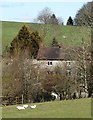
5
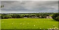
Kniveton
Kniveton seen from Standlow Lane.
Image: © Peter McDermott
Taken: 28 Aug 2023
0.24 miles
6
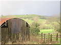
A rusty old barn adjacent to Newhouse Farm
The Peak District National Park just visible in the distance.
Image: © Dr Duncan Pepper
Taken: 23 Jan 2014
0.24 miles
7
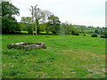
View from Standlow Lane
Looking south across land south of Standlow Farm.
Image: © Jonathan Billinger
Taken: 26 May 2010
0.24 miles
8
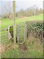
Footpath originating below Newhouse Farm
A charming little wicket gate too.
Image: © Dr Duncan Pepper
Taken: 23 Jan 2014
0.25 miles