IMAGES TAKEN NEAR TO
Peter Street, ASHBOURNE, DE6 1FP
Introduction
This page details the photographs taken nearby to Peter Street, DE6 1FP by members of the Geograph project.
The Geograph project started in 2005 with the aim of publishing, organising and preserving representative images for every square kilometre of Great Britain, Ireland and the Isle of Man.

There are currently over 7.5m images from over14,400 individuals and you can help contribute to the project by visiting https://www.geograph.org.uk
Image Map
Images are licensed for reuse under creativecommons.org/licenses/by-sa/2.0
Notes
- Clicking on the map will re-center to the selected point.
- The higher the marker number, the further away the image location is from the centre of the postcode.
Image Listing (382 Images Found)
Images are licensed for reuse under creativecommons.org/licenses/by-sa/2.0
Image
Details
Distance
1
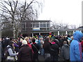
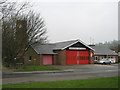
Royal Shrovetide at the Ambulance Station
Staff in the ambulance station get a view of the 'hug'.
Image: © John M
Taken: 12 Feb 2013
0.04 miles
2
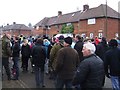
Royal Shrovetide in Park Avenue
An unusual excursion into the Council Estate by the 'hug'.
Image: © John M
Taken: 12 Feb 2013
0.05 miles
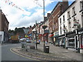
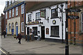
4
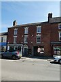
House with arched entrance, Compton Street, Ashbourne
The shopfront is, presumably, an addition
Image: © David Smith
Taken: 30 Apr 2022
0.06 miles
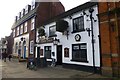
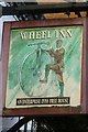
9
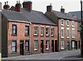
The Wheel Inn
Yet another Ashbourne pub.
Image: © Malcolm Neal
Taken: 15 Apr 2017
0.08 miles