
IMAGES TAKEN NEAR TO
Warmwells Lane, RIPLEY, DE5 8JE
Introduction
This page details the photographs taken nearby to Warmwells Lane, DE5 8JE by members of the Geograph project.
The Geograph project started in 2005 with the aim of publishing, organising and preserving representative images for every square kilometre of Great Britain, Ireland and the Isle of Man.

There are currently over 7.5m images from over14,400 individuals and you can help contribute to the project by visiting https://www.geograph.org.uk
Image Map
Images are licensed for reuse under creativecommons.org/licenses/by-sa/2.0
Notes
- Clicking on the map will re-center to the selected point.
- The higher the marker number, the further away the image location is from the centre of the postcode.
Image Listing (26 Images Found)
Images are licensed for reuse under creativecommons.org/licenses/by-sa/2.0
Image
Details
Distance
3
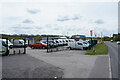
Van sales
If you want a van this is one of the places to come to.
Image: © Malcolm Neal
Taken: 13 May 2021
0.11 miles
4
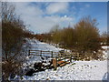
Footbridge, Ripley Greenway
A bridge in an area of reclaimed land, formerly clay pits, Ripley.
Image: © Peter Barr
Taken: 29 Nov 2010
0.11 miles
5
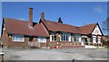
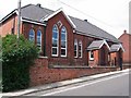
Marehay - Miners Welfare (from SE)
On Derby Road. Please see Image for an alternative view.
Image: © Dave Bevis
Taken: 18 Apr 2015
0.12 miles
6
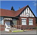
Marehay - Miners Welfare (from E)
On Derby Road. Date stone above windows shows "1923".
Image: © Dave Bevis
Taken: 18 Apr 2015
0.12 miles
7
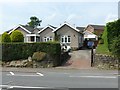
House at Marehay
Taken to show the location of the old cast iron milepost http://www.geograph.org.uk/photo/5436370 , in the roadside rockery to the left of the gateway.
Image: © Alan Murray-Rust
Taken: 19 Jun 2017
0.12 miles

9
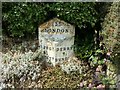
Milepost at Marehay
Triangular cast iron, early 19th century, Listed Grade II. The road, now the B6179 but formerly the A61, was the old Derby to Alfreton turnpike. See http://www.geograph.org.uk/photo/5436373 for location.
Image: © Alan Murray-Rust
Taken: 19 Jun 2017
0.12 miles
10
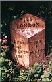
Old Milepost by the B6179, south of Ripley
Cast iron post by the B6179, in parish of RIPLEY (AMBER VALLEY District), Derby Road, Marehay, in hedge, on West side of road. Alfreton iron casting, erected by the Alfreton & Derby turnpike trust in the 19th century.
Inscription reads:-
: ALFRE.N / 4½ / CHEST.D / 15 : : 135 / LONDON : : DERBY / 9½ / BURTON / 20 :
Grade II Listed. List Entry Number:1159018
https://historicengland.org.uk/listing/the-list/list-entry/1159018
Milestone Society National ID: DE_AFDE04.
Image: © J Higgins
Taken: 1 May 2002
0.12 miles