
IMAGES TAKEN NEAR TO
Holly Lane, BELPER, DE56 2HG
Introduction
This page details the photographs taken nearby to Holly Lane, DE56 2HG by members of the Geograph project.
The Geograph project started in 2005 with the aim of publishing, organising and preserving representative images for every square kilometre of Great Britain, Ireland and the Isle of Man.

There are currently over 7.5m images from over14,400 individuals and you can help contribute to the project by visiting https://www.geograph.org.uk
Image Map
Images are licensed for reuse under creativecommons.org/licenses/by-sa/2.0
Notes
- Clicking on the map will re-center to the selected point.
- The higher the marker number, the further away the image location is from the centre of the postcode.
Image Listing (16 Images Found)
Images are licensed for reuse under creativecommons.org/licenses/by-sa/2.0
Image
Details
Distance
1

Road junction and field
The road junction at the end of Whitewells lane, looking across the grassy field towards Crich Stand.
Image: © John Poyser
Taken: 1 May 2008
0.09 miles

3

Holly lane bridleway
The start of the bridleway into The Birches.
Image: © John Poyser
Taken: 30 Apr 2008
0.12 miles

5

Junction of Holly Lane and Whitewells Lane, Ambergate, Derbyshire
Finger post road sign with Alderwasley and Ashlehay missing.
Image: © Martin Froggatt
Taken: 14 May 2020
0.13 miles
6

Bridleway through The Birches
The bridleway through The Birches and on up to Shining Cliff Woods.
Image: © John Poyser
Taken: 1 May 2008
0.15 miles


9
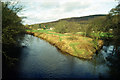
Rivers Derwent and Amber, Ambergate
This shows the confluence of the River Derwent (to the left) and its tributary, the Amber. The valleys of these rivers, coming together here, made Ambergate an important road and rail junction, although there is not much to the village itself.
Image: © Stephen McKay
Taken: Unknown
0.17 miles
10

Valley side, Ambergate
The wood across the valley is The Birches. Cattle graze in open birch woodland nearer at hand. The view is from a train between Chesterfield and Derby, but the parapet in the foreground is actually beside the Derwent valley line; the tracks meet a little behind the camera.
Image: © Derek Harper
Taken: 6 Apr 2012
0.19 miles