IMAGES TAKEN NEAR TO
Maple Drive, BELPER, DE56 1LR
Introduction
This page details the photographs taken nearby to Maple Drive, DE56 1LR by members of the Geograph project.
The Geograph project started in 2005 with the aim of publishing, organising and preserving representative images for every square kilometre of Great Britain, Ireland and the Isle of Man.

There are currently over 7.5m images from over14,400 individuals and you can help contribute to the project by visiting https://www.geograph.org.uk
Image Map
Images are licensed for reuse under creativecommons.org/licenses/by-sa/2.0
Notes
- Clicking on the map will re-center to the selected point.
- The higher the marker number, the further away the image location is from the centre of the postcode.
Image Listing (4 Images Found)
Images are licensed for reuse under creativecommons.org/licenses/by-sa/2.0
Image
Details
Distance
1
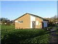
Changing rooms at Manor Recreation Ground
Image: © Ian Calderwood
Taken: 29 Nov 2019
0.08 miles
2
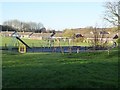
Children's play area in Manor Recreation Ground
Manor Recreation Ground is part of Belper Parks.
Image: © Ian Calderwood
Taken: 29 Nov 2019
0.11 miles
3
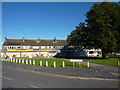
Chestnut Avenue, Belper
Convenience store,Finance company closed, and two take-aways.
Image: © Peter Barr
Taken: 25 Sep 2010
0.18 miles
4
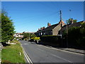
Mill Lane, Belper
Welcome Tavern, a pub, looking like its neighbouring houses.
Image: © Peter Barr
Taken: 25 Sep 2010
0.21 miles