IMAGES TAKEN NEAR TO
Laund Close, BELPER, DE56 1ET
Introduction
This page details the photographs taken nearby to Laund Close, DE56 1ET by members of the Geograph project.
The Geograph project started in 2005 with the aim of publishing, organising and preserving representative images for every square kilometre of Great Britain, Ireland and the Isle of Man.

There are currently over 7.5m images from over14,400 individuals and you can help contribute to the project by visiting https://www.geograph.org.uk
Image Map
Images are licensed for reuse under creativecommons.org/licenses/by-sa/2.0
Notes
- Clicking on the map will re-center to the selected point.
- The higher the marker number, the further away the image location is from the centre of the postcode.
Image Listing (9 Images Found)
Images are licensed for reuse under creativecommons.org/licenses/by-sa/2.0
Image
Details
Distance
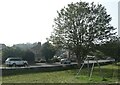
1
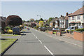
The view from The Spinney
The Spinney is a short cul-de-sac with views over Belper.
Image: © Ian Calderwood
Taken: 29 Nov 2019
0.08 miles
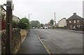
2
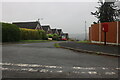
Far Laund
Far Laund is a strangely named road that runs into the north of the small town of Belper.
Image: © Malcolm Neal
Taken: 15 May 2018
0.10 miles
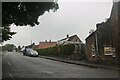
3
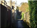
Footpath to Heage crossing Coronation Avenue
A former field path now hemmed in by housing heading up towards the phone mast on Bessalone.
Image: © Ian Calderwood
Taken: 29 Nov 2019
0.13 miles
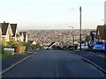
5
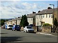
Crich Lane, Belper
Looking down towards the town centre.
Image: © Stephen McKay
Taken: 3 Sep 2006
0.16 miles