IMAGES TAKEN NEAR TO
Sandbed Lane, BELPER, DE56 0SH
Introduction
This page details the photographs taken nearby to Sandbed Lane, DE56 0SH by members of the Geograph project.
The Geograph project started in 2005 with the aim of publishing, organising and preserving representative images for every square kilometre of Great Britain, Ireland and the Isle of Man.

There are currently over 7.5m images from over14,400 individuals and you can help contribute to the project by visiting https://www.geograph.org.uk
Image Map
Images are licensed for reuse under creativecommons.org/licenses/by-sa/2.0
Notes
- Clicking on the map will re-center to the selected point.
- The higher the marker number, the further away the image location is from the centre of the postcode.
Image Listing (23 Images Found)
Images are licensed for reuse under creativecommons.org/licenses/by-sa/2.0
Image
Details
Distance
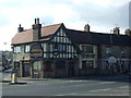
1
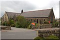
St Marks Church, Openwoodgate.
The wrought iron gates to this church were made and erected as a memorial for the second world war.
Image: © Ian Wigley
Taken: 4 Oct 2006
0.03 miles
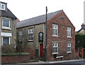
5
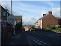
Entering Belper
Heading north west on the A609.
Image: © JThomas
Taken: 20 Oct 2015
0.06 miles
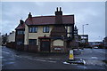
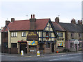
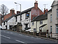
7
The Hop Inn
A pub with a very innovative name that works on several levels. It is at the junction of Over Lane and Sandbed Lane where they cross the A609.
Image: © Malcolm Neal
Taken: 5 Oct 2017
0.06 miles

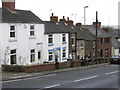
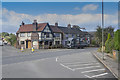
10
Openwoodgate - Seven Stars
On Kilbourne Road. For an alternative view, please see Image
Image: © Dave Bevis
Taken: 8 Mar 2012
0.07 miles