IMAGES TAKEN NEAR TO
Queensway, ALFRETON, DE55 6LE
Introduction
This page details the photographs taken nearby to Queensway, DE55 6LE by members of the Geograph project.
The Geograph project started in 2005 with the aim of publishing, organising and preserving representative images for every square kilometre of Great Britain, Ireland and the Isle of Man.

There are currently over 7.5m images from over14,400 individuals and you can help contribute to the project by visiting https://www.geograph.org.uk
Image Map
Images are licensed for reuse under creativecommons.org/licenses/by-sa/2.0
Notes
- Clicking on the map will re-center to the selected point.
- The higher the marker number, the further away the image location is from the centre of the postcode.
Image Listing (8 Images Found)
Images are licensed for reuse under creativecommons.org/licenses/by-sa/2.0
Image
Details
Distance
1
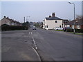
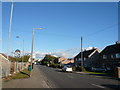
Stonebroom housing estate
The houses of the estate were originally owned by the Coal Board to provide housing for Derbyshire's miners. The estate underwent a makeover during the late 1990s, when many of the buildings were clad with brick.
Image: © Nikki Mahadevan
Taken: 1 Sep 2006
0.04 miles
2
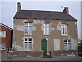
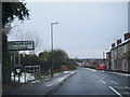
Stonebroom - The Double Six
Birkinstyle Lane
Image: © Alan Heardman
Taken: 17 Oct 2007
0.11 miles
3
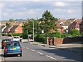
Stonebroom - Street view from the Double Six
Image: © Alan Heardman
Taken: 17 Oct 2007
0.12 miles
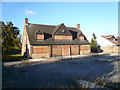
5
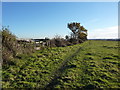
Field, footpath and a glimpse of pre-fabs
Stonebroom, North- east Derbyshire, former mining village.
Image: © Peter Barr
Taken: 26 Nov 2010
0.17 miles
6
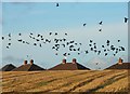
Crows Over a Field
Between Dog Lane and Stonebroom with some Byron Grove rooftops in view.
Image: © Neil Theasby
Taken: 11 Dec 2015
0.20 miles