IMAGES TAKEN NEAR TO
Carlyle Road, ALFRETON, DE55 6HX
Introduction
This page details the photographs taken nearby to Carlyle Road, DE55 6HX by members of the Geograph project.
The Geograph project started in 2005 with the aim of publishing, organising and preserving representative images for every square kilometre of Great Britain, Ireland and the Isle of Man.

There are currently over 7.5m images from over14,400 individuals and you can help contribute to the project by visiting https://www.geograph.org.uk
Image Map
Images are licensed for reuse under creativecommons.org/licenses/by-sa/2.0
Notes
- Clicking on the map will re-center to the selected point.
- The higher the marker number, the further away the image location is from the centre of the postcode.
Image Listing (7 Images Found)
Images are licensed for reuse under creativecommons.org/licenses/by-sa/2.0
Image
Details
Distance
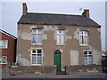
5
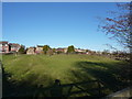
Houses and farm at Stonebroom
A former mining village.
The village is linear and was formed from two hamlets, early maps show them as Upper Stone and Lower Stone. The School playing field was once the site of a quarry, this is still called Quarry Lane. It is probable that the name Stonebroom was derived from this quarry which provided stone, it is said that the field behind the quarry was full of broom, which gave one possible explanation for the unusual village name. (Wikipedia)
Image: © Peter Barr
Taken: 26 Nov 2010
0.18 miles
6
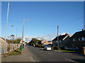
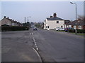
Stonebroom - Street view from the Double Six
Image: © Alan Heardman
Taken: 17 Oct 2007
0.19 miles
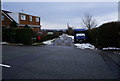
7
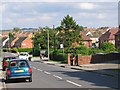
Stonebroom housing estate
The houses of the estate were originally owned by the Coal Board to provide housing for Derbyshire's miners. The estate underwent a makeover during the late 1990s, when many of the buildings were clad with brick.
Image: © Nikki Mahadevan
Taken: 1 Sep 2006
0.21 miles