IMAGES TAKEN NEAR TO
Sycamore Close, ALFRETON, DE55 6GQ
Introduction
This page details the photographs taken nearby to Sycamore Close, DE55 6GQ by members of the Geograph project.
The Geograph project started in 2005 with the aim of publishing, organising and preserving representative images for every square kilometre of Great Britain, Ireland and the Isle of Man.

There are currently over 7.5m images from over14,400 individuals and you can help contribute to the project by visiting https://www.geograph.org.uk
Image Map
Images are licensed for reuse under creativecommons.org/licenses/by-sa/2.0
Notes
- Clicking on the map will re-center to the selected point.
- The higher the marker number, the further away the image location is from the centre of the postcode.
Image Listing (20 Images Found)
Images are licensed for reuse under creativecommons.org/licenses/by-sa/2.0
Image
Details
Distance
1

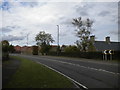
View towards Mickley Estate
From road by Yew Tree Farm
Image: © Chris Morgan
Taken: 26 Jun 2019
0.04 miles
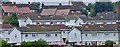
2
A61 approaching Mickley Estate
Passing Pingle Farm.
Image: © Richard Vince
Taken: 13 Oct 2018
0.10 miles
4
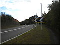
A61 past Mickley Estate (2)
Looking towards Derby.
Image: © Richard Vince
Taken: 13 Oct 2018
0.17 miles
5
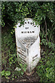
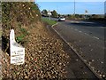
Ryknild Street milepost
Milepost on Ryknild Street A61 at Higham
Clay Cross 2 miles
Chesterfield 7 miles
Sheffield 19 miles
Derby 16 miles
Image: © Richard Croft
Taken: 14 Jun 2010
0.19 miles
7
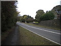
A61 past Mickley Estate (1)
Looking towards Chesterfield.
Image: © Richard Vince
Taken: 13 Oct 2018
0.19 miles
8
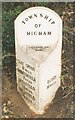
Old Milepost by the A61, north of Higham
Cast iron post by the A61, in parish of Shirland and Higham (North East Derbyshire District), Main Road; North of Higham, 14m North of Quarry Farmhouse, opposite Greyhound PH, on grass verge in front hedge, on West side of road. Haywood iron casting, erected by the Duffield & Sheffield turnpike trust in the 19th century.
Inscription reads:-
: CLAY CROSS / 2 MILES / CHESTERFIELD / 7 MILES / DRONFIELD / 13 MILES / SHEFFIELD / 19 MILES : : TOWNSHIP / OF / HIGHAM : : DERBY / 16 MILES :
Maker:-
: J. HAYWOOD JUNᴿ / PHOENIX FOUNDRY / DERBY :
Grade II listed.
List Entry Number: 1158845 https://historicengland.org.uk/listing/the-list/list-entry/1158845
Milestone Society National ID: DE_DECF16
Image: © J Higgins
Taken: 1 Oct 2002
0.19 miles
9
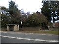
Bus stop and footpath, Mickley Estate
The path links the bus stop, on the A61, with Hawthorne Avenue.
Image: © Richard Vince
Taken: 13 Oct 2018
0.20 miles
10
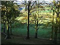
Looking down into the Valley from the A61
Looking through beech trees lining the hillside above the Amber Valley. The dam end of Ogston Reservoir can just be seen in the distance.
Image: © Nikki Mahadevan
Taken: 30 Oct 2007
0.20 miles