IMAGES TAKEN NEAR TO
Mathers Grave Lane, ALFRETON, DE55 6ED
Introduction
This page details the photographs taken nearby to Mathers Grave Lane, DE55 6ED by members of the Geograph project.
The Geograph project started in 2005 with the aim of publishing, organising and preserving representative images for every square kilometre of Great Britain, Ireland and the Isle of Man.

There are currently over 7.5m images from over14,400 individuals and you can help contribute to the project by visiting https://www.geograph.org.uk
Image Map
Images are licensed for reuse under creativecommons.org/licenses/by-sa/2.0
Notes
- Clicking on the map will re-center to the selected point.
- The higher the marker number, the further away the image location is from the centre of the postcode.
Image Listing (25 Images Found)
Images are licensed for reuse under creativecommons.org/licenses/by-sa/2.0
Image
Details
Distance

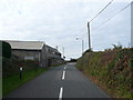
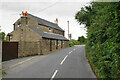
2
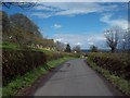
Mathersgrave Lane near Brackenfield
Approaching the junction with School Lane.
Image: © Jonathan Clitheroe
Taken: 21 Apr 2012
0.03 miles
3
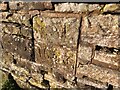
Gravestone at Mathersgrave
Gravestone inscribed SM 1643 in memory of Samuel Mather who was buried at the cross roads.
Image: © Andrew Hardwick
Taken: 12 Jan 2021
0.04 miles
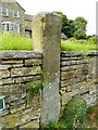
4
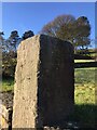
Mathersgrave Guidepost
Grade II Listed Building
Inscribed:
Ashover Road, Matlock Road and Bakewell Road
Image: © Andrew Hardwick
Taken: 12 Jan 2021
0.04 miles
5
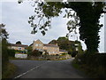
Mathersgrave Lane - Junction with School Lane
Image: © Alan Heardman
Taken: 30 Sep 2007
0.06 miles
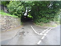
6
Mathersgrave Lane - Approaching Junction with Matlock Road
Image: © Alan Heardman
Taken: 30 Sep 2007
0.08 miles
7
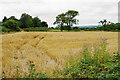
Small barley field by Mathersgrave Lane
Viewed from Matlock Road.
Image: © Bill Boaden
Taken: 31 Jul 2021
0.09 miles
8
Minor road junction, Mathersgrave
Coldharbour Lane branches off from White Carr Lane.
Image: © JThomas
Taken: 28 Jul 2016
0.09 miles
9
Stoop way sign and Mathers Grave at Mathersgrave
Stone stoop (a way sign) built into a wall beside Mather's marker stone (covered in ivy). Mather was highwayman who was reputedly buried (and hung) at the crossroads as was the customary practice in days gone by.
Image: © Rob Howl
Taken: 10 Sep 2012
0.09 miles
10
Mathersgrave Lane
The western end where it meets the A615.
Image: © Bill Boaden
Taken: 31 Jul 2021
0.09 miles