IMAGES TAKEN NEAR TO
Main Road, ALFRETON, DE55 6BA
Introduction
This page details the photographs taken nearby to Main Road, DE55 6BA by members of the Geograph project.
The Geograph project started in 2005 with the aim of publishing, organising and preserving representative images for every square kilometre of Great Britain, Ireland and the Isle of Man.

There are currently over 7.5m images from over14,400 individuals and you can help contribute to the project by visiting https://www.geograph.org.uk
Image Map
Images are licensed for reuse under creativecommons.org/licenses/by-sa/2.0
Notes
- Clicking on the map will re-center to the selected point.
- The higher the marker number, the further away the image location is from the centre of the postcode.
Image Listing (32 Images Found)
Images are licensed for reuse under creativecommons.org/licenses/by-sa/2.0
Image
Details
Distance
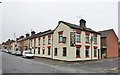
1
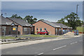
Houses nearing completion
These new bungalows are on the edge of Shirland. Obviously not finished as most are surrounded by security fencing.
Image: © Malcolm Neal
Taken: 1 Jul 2018
0.03 miles
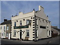
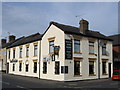
2
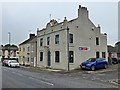
The Hay Hotel
Public house on the corner of Main Road and Greaves Street, Shirland
Image: © Graham Hogg
Taken: 26 Jun 2019
0.03 miles
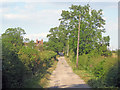
5
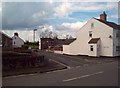
Greaves Street in Shirland
Taken from Park Lane at the eastern edge of the village.
Image: © Jonathan Clitheroe
Taken: 21 Apr 2012
0.05 miles
6
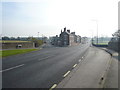
Shirland - Junction of Main Road (A61) and Park Lane
Image: © Alan Heardman
Taken: 4 Nov 2007
0.06 miles

9
Cross Lane
Heading east to join Main Road (A61) at Shirland near the large house.
Image: © Trevor Rickard
Taken: 2 Jul 2011
0.13 miles