
IMAGES TAKEN NEAR TO
Tiree Close, ALFRETON, DE55 5QX
Introduction
This page details the photographs taken nearby to Tiree Close, DE55 5QX by members of the Geograph project.
The Geograph project started in 2005 with the aim of publishing, organising and preserving representative images for every square kilometre of Great Britain, Ireland and the Isle of Man.

There are currently over 7.5m images from over14,400 individuals and you can help contribute to the project by visiting https://www.geograph.org.uk
Image Map
Images are licensed for reuse under creativecommons.org/licenses/by-sa/2.0
Notes
- Clicking on the map will re-center to the selected point.
- The higher the marker number, the further away the image location is from the centre of the postcode.
Image Listing (45 Images Found)
Images are licensed for reuse under creativecommons.org/licenses/by-sa/2.0
Image
Details
Distance
1
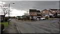
Staffa Drive
This southerly facing photograph shows Staffa Drive at its junction with Tiree Close.
Ahead Shetland Road has a Image
A short distance behind the viewpoint is a small Image through which there is access to the Five Pits Trail.
Image: © Alan Walker
Taken: 4 Feb 2018
0.05 miles
2
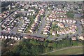
Estate Housing, Tibshelf - Aerial Photo
The photo was taken during a helicopter ride. It shows housing either side of Tibshelf High Street. The main road around the housing is Staffa Drive.
Image: © Nikki Mahadevan
Taken: 27 Sep 2003
0.06 miles
3
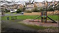
Children's play area
This small children's play area is between the eastern end of Image and the Image to which there is access behind the viewpoint.
Image: © Alan Walker
Taken: 4 Feb 2018
0.06 miles
4
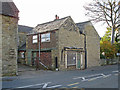
Tibshelf - former butcher's shop
On High Street, opposite the Methodist Church.
Image: © Dave Bevis
Taken: 19 Oct 2014
0.06 miles
6

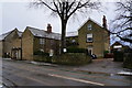
High Street, Tibshelf
The Royal Oak has become The Twisted Oak, inviting speculation as to the reason for the change. The building behind the sign is a Methodist Chapel.
Image: © Humphrey Bolton
Taken: 2 Feb 2018
0.08 miles
7
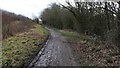
Five Pits Trail
This southerly facing photograph of the Five Pits Trail https://www.derbyshire.gov.uk/images/5%20Pits%20lft%20Jan%202014%20web_tcm44-216030.pdf was taken from a point just above a Image on Image in Tibshelf the access to which can be seen on the right.
Ahead, the trail continues toward Tibshelf Ponds and the Silverhill Trail https://www.derbyshire.gov.uk/images/Silverhill%20Trail%20panel_tcm44-146878.pdf .
Image: © Alan Walker
Taken: 4 Feb 2018
0.08 miles
8
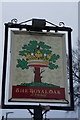
The Royal Oak, Tibshelf
http://www.geograph.org.uk/photo/4334317 http://www.geograph.org.uk/photo/4334321
Image: © Ian S
Taken: 31 Jan 2015
0.08 miles
9
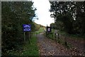
Tibshelf canter track access
A recently restored countryside route for horses alongside the Five Pits Trail
Image: © Graham Hogg
Taken: 28 Oct 2013
0.08 miles
10

Tibshelf
The Slap & Tickle public house (disused).
Image: © Alan Heardman
Taken: 19 Oct 2007
0.08 miles