IMAGES TAKEN NEAR TO
Bramble Way, ALFRETON, DE55 4RH
Introduction
This page details the photographs taken nearby to Bramble Way, DE55 4RH by members of the Geograph project.
The Geograph project started in 2005 with the aim of publishing, organising and preserving representative images for every square kilometre of Great Britain, Ireland and the Isle of Man.

There are currently over 7.5m images from over14,400 individuals and you can help contribute to the project by visiting https://www.geograph.org.uk
Image Map
Images are licensed for reuse under creativecommons.org/licenses/by-sa/2.0
Notes
- Clicking on the map will re-center to the selected point.
- The higher the marker number, the further away the image location is from the centre of the postcode.
Image Listing (9 Images Found)
Images are licensed for reuse under creativecommons.org/licenses/by-sa/2.0
Image
Details
Distance
1
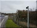
Partial foot-path sign
Resilient footpath; it's still there, right in the middle of an industrial estate, and about to be walked on for probably the first time in months.
Image: © Peter Barr
Taken: 14 Nov 2011
0.03 miles
3
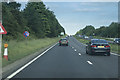
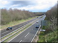
A38 Road as seen from Birchwood Lane
Looking west on an overcast Easter Saturday.
Image: © Jonathan Clitheroe
Taken: 7 Apr 2012
0.11 miles
4
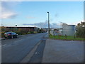
Clover Nook industrial estate
A major industrial estate on the east side of Alfreton.
Image: © Richard Law
Taken: 4 Nov 2016
0.12 miles
5

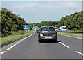
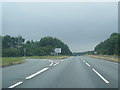
South Normanton : A38
Heading along the A38.
Image: © Lewis Clarke
Taken: 25 Sep 2020
0.12 miles
6
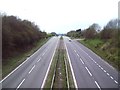
A38 near South Normanton
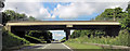
A view of the A38 taken from the bridge leading up to the village of South Normanton.
Image: © Mike Bardill
Taken: 2 Apr 2006
0.13 miles