IMAGES TAKEN NEAR TO
Azalea Close, ALFRETON, DE55 4QX
Introduction
This page details the photographs taken nearby to Azalea Close, DE55 4QX by members of the Geograph project.
The Geograph project started in 2005 with the aim of publishing, organising and preserving representative images for every square kilometre of Great Britain, Ireland and the Isle of Man.

There are currently over 7.5m images from over14,400 individuals and you can help contribute to the project by visiting https://www.geograph.org.uk
Image Map
Images are licensed for reuse under creativecommons.org/licenses/by-sa/2.0
Notes
- Clicking on the map will re-center to the selected point.
- The higher the marker number, the further away the image location is from the centre of the postcode.
Image Listing (9 Images Found)
Images are licensed for reuse under creativecommons.org/licenses/by-sa/2.0
Image
Details
Distance
1
Bluebell Close
A horticulturally challenged name for a road in an industrial estate, off Clover Nook Road.
Image: © Peter Barr
Taken: 14 Nov 2011
0.07 miles
4
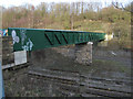
Somercotes - Cotes Park railway footbridge
Recently re-built.
Image: © Dave Bevis
Taken: 22 Jan 2012
0.22 miles
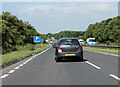
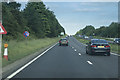
5
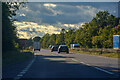
South Normanton : A38
Heading along the A38.
Image: © Lewis Clarke
Taken: 25 Sep 2020
0.22 miles
6

South Normanton : A38
Heading along the A38.
Image: © Lewis Clarke
Taken: 25 Sep 2020
0.22 miles
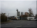
7
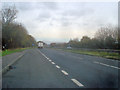
Lay-by at Alfreton
Looking east along the A38 with Cotes Park industrial estate on the right.
Image: © Trevor Rickard
Taken: 31 Oct 2009
0.23 miles
8
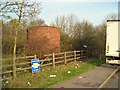
Air shaft
This unassuming brick structure sitting beside a layby on the A38 is an air shaft for ventilating the Alfreton railway tunnel, which passes under the road here. A footpath passes by just behind it. The notice on the fence is to warn lorry drivers of the danger of having their load stolen here.
Image: © Antony Dixon
Taken: 23 Nov 2011
0.25 miles