IMAGES TAKEN NEAR TO
Ball Hill, ALFRETON, DE55 2ED
Introduction
This page details the photographs taken nearby to Ball Hill, DE55 2ED by members of the Geograph project.
The Geograph project started in 2005 with the aim of publishing, organising and preserving representative images for every square kilometre of Great Britain, Ireland and the Isle of Man.

There are currently over 7.5m images from over14,400 individuals and you can help contribute to the project by visiting https://www.geograph.org.uk
Image Map
Images are licensed for reuse under creativecommons.org/licenses/by-sa/2.0
Notes
- Clicking on the map will re-center to the selected point.
- The higher the marker number, the further away the image location is from the centre of the postcode.
Image Listing (19 Images Found)
Images are licensed for reuse under creativecommons.org/licenses/by-sa/2.0
Image
Details
Distance
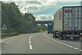
3

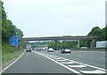
Ball Hill
The road is about to cross over the M1.
Image: © Bill Boaden
Taken: 5 Oct 2021
0.07 miles
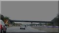
4
Bridge over the MI, with 'speeding' sign
Image: © Christine Johnstone
Taken: 31 Oct 2009
0.07 miles
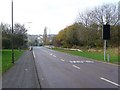
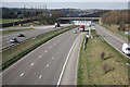
5
Bolsover District : M1 Motorway
The M1 Motorway between Junction 29 and Junction 28.
Image: © Lewis Clarke
Taken: 3 Oct 2018
0.08 miles
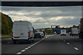
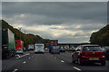
6

South Normanton : M1 Motorway
Heading southbound on the M1 Motorway.
Image: © Lewis Clarke
Taken: 25 Sep 2020
0.10 miles
7
Bolsover District : M1 Motorway
The M1 Motorway between Junction 29 and Junction 28.
Image: © Lewis Clarke
Taken: 2 Oct 2018
0.10 miles
8

The M1 near South Normanton
Viewed from Ball Hill. The sliproads lead to Junction 28.
Image: © Bill Boaden
Taken: 5 Oct 2021
0.11 miles
9
M1 north
View north from Carter Lane footbridge
Image: © Richard Croft
Taken: 23 Mar 2011
0.14 miles
10
Bolsover District : M1 Motorway
The M1 Motorway between Junction 29 and Junction 28.
Image: © Lewis Clarke
Taken: 3 Oct 2018
0.15 miles