IMAGES TAKEN NEAR TO
Aqueduct Drive, DE5 3QJ
Introduction
This page details the photographs taken nearby to Aqueduct Drive, DE5 3QJ by members of the Geograph project.
The Geograph project started in 2005 with the aim of publishing, organising and preserving representative images for every square kilometre of Great Britain, Ireland and the Isle of Man.

There are currently over 7.5m images from over14,400 individuals and you can help contribute to the project by visiting https://www.geograph.org.uk
Image Map
Images are licensed for reuse under creativecommons.org/licenses/by-sa/2.0
Notes
- Clicking on the map will re-center to the selected point.
- The higher the marker number, the further away the image location is from the centre of the postcode.
Image Listing (11 Images Found)
Images are licensed for reuse under creativecommons.org/licenses/by-sa/2.0
Image
Details
Distance
1
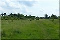
Open land at Coppice Farm
A notice on the site http://www.geograph.org.uk/photo/5436361 expressly allows the area to be used for recreational purposes. The further part of the area was being mown for hay.
Image: © Alan Murray-Rust
Taken: 19 Jun 2017
0.13 miles
2
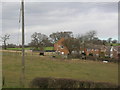
Town meets country
The very edge of suburban housing at Waingroves, Derbyshire.
Image: © John H Darch
Taken: 6 Mar 2006
0.15 miles
3
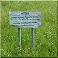
Unexpected notice
From a distance I was expecting this to be a standard 'keep off' type notice, but surprisingly it is anything but.
Image: © Alan Murray-Rust
Taken: 19 Jun 2017
0.15 miles
4
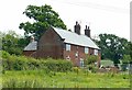
Coppice Farmhouse, Peasehill
Late 18th century farmhouse with prominent kneelers to the gables, although many of the windows have been subject to 20th century modification. Listed Grade II.
Image: © Alan Murray-Rust
Taken: 19 Jun 2017
0.17 miles
5
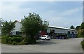
Benjamin Outram Business Centre, Peasehill, Ripley
Industrial units developed by Amber Valley Council, on the site of a former railway goods yard, formerly the terminus of the Ripley branch of the Midland Railway. The name commemorates the founder of the Butterley Company.
Image: © Alan Murray-Rust
Taken: 19 Jun 2017
0.18 miles
6
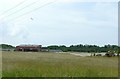
Former Waingroves Brickworks site
Originally part of the Butterley Company empire, in latter days part of the Hanson Group, now named Forterra. Although brick manufacturing ceased in 2006, the owners currently (2017) have a continuing license for mineral (clay) extraction on the site.
Image: © Alan Murray-Rust
Taken: 19 Jun 2017
0.19 miles
7

View of Waingroves
Houses on Queen Street seen from the site of the old Waingroves Colliery
Image: © Alan Murray-Rust
Taken: 25 Oct 2011
0.22 miles
8

Jolly Colliers pub
Located on Jessop Street Waingroves, now a disused public house.
Image: © sheral wood
Taken: 22 Aug 2007
0.23 miles