IMAGES TAKEN NEAR TO
Sandham Lane, RIPLEY, DE5 3HE
Introduction
This page details the photographs taken nearby to Sandham Lane, DE5 3HE by members of the Geograph project.
The Geograph project started in 2005 with the aim of publishing, organising and preserving representative images for every square kilometre of Great Britain, Ireland and the Isle of Man.

There are currently over 7.5m images from over14,400 individuals and you can help contribute to the project by visiting https://www.geograph.org.uk
Image Map
Images are licensed for reuse under creativecommons.org/licenses/by-sa/2.0
Notes
- Clicking on the map will re-center to the selected point.
- The higher the marker number, the further away the image location is from the centre of the postcode.
Image Listing (5 Images Found)
Images are licensed for reuse under creativecommons.org/licenses/by-sa/2.0
Image
Details
Distance
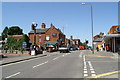
1

South end of Cedar Avenue, Ripley
Seen from Elms Avenue.
Image: © Richard Vince
Taken: 13 May 2017
0.24 miles
2

Bernard Boam Flats, Ripley
At the junction of Cedar Avenue (left) and Elms Avenue.
Image: © Richard Vince
Taken: 13 May 2017
0.24 miles
3
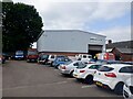
Malthouse Yard Car Park
Ripley shoppers car park and B K Autos Recoveries
Image: © Richard Webb
Taken: 30 May 2023
0.25 miles
4
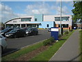
Ripley Leisure Centre
Modern facility situated on Derby Road.
Image: © Trevor Rickard
Taken: 22 May 2011
0.25 miles