IMAGES TAKEN NEAR TO
DE5 0LY
Introduction
This page details the photographs taken nearby to DE5 0LY by members of the Geograph project.
The Geograph project started in 2005 with the aim of publishing, organising and preserving representative images for every square kilometre of Great Britain, Ireland and the Isle of Man.

There are currently over 7.5m images from over14,400 individuals and you can help contribute to the project by visiting https://www.geograph.org.uk
Image Map
Images are licensed for reuse under creativecommons.org/licenses/by-sa/2.0
Notes
- Clicking on the map will re-center to the selected point.
- The higher the marker number, the further away the image location is from the centre of the postcode.
Image Listing (29 Images Found)
Images are licensed for reuse under creativecommons.org/licenses/by-sa/2.0
Image
Details
Distance
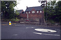
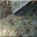
2
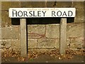
Bench mark, Horsley Road, Kilburn
See http://www.geograph.org.uk/photo/5467571 for location.
Image: © Alan Murray-Rust
Taken: 17 Jul 2017
0.07 miles
3
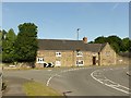
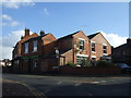
Hall Farmhouse, Kilburn
Possibly 18th century.
There is a bench mark http://www.geograph.org.uk/photo/5467568 below the road name sign far left.
Image: © Alan Murray-Rust
Taken: 17 Jul 2017
0.07 miles
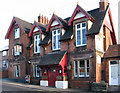
4
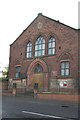
Kilburn Baptist Church
Kilburn Baptist Church, Kilburn, Derbyshire, SK380456
Image: © Rob Bradford
Taken: 30 May 2005
0.11 miles
5
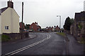
A609, Horsley, Road Junction, Kilburn
A609, Horsley-Lower Kilburn, Road Junction, Kilburn, Derbyshire, SK377455
Image: © Rob Bradford
Taken: 30 May 2005
0.11 miles
6
Kilburn War Memorial
Kilburn War Memorial, Kilburn, Derbyshire, Junction of A609 and Church Street showing the awful mini painted lump road traffic island! SK378458
Image: © Rob Bradford
Taken: 30 May 2005
0.12 miles
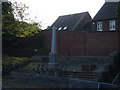
7
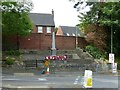
Kilburn War Memorial
The granite obelisk was erected to commemorate villagers who died in the Boer War. Additional commemorative tablets have been added for the victims of the two World Wars. Listed Grade II.
Image: © Alan Murray-Rust
Taken: 19 Jun 2017
0.12 miles
8
Rivet bench mark, Church Street, Kilburn
See http://www.geograph.org.uk/photo/5465076 for location.
Image: © Alan Murray-Rust
Taken: 9 Jul 2017
0.12 miles