IMAGES TAKEN NEAR TO
DE5 0DS
Introduction
This page details the photographs taken nearby to DE5 0DS by members of the Geograph project.
The Geograph project started in 2005 with the aim of publishing, organising and preserving representative images for every square kilometre of Great Britain, Ireland and the Isle of Man.

There are currently over 7.5m images from over14,400 individuals and you can help contribute to the project by visiting https://www.geograph.org.uk
Image Map
Images are licensed for reuse under creativecommons.org/licenses/by-sa/2.0
Notes
- Clicking on the map will re-center to the selected point.
- The higher the marker number, the further away the image location is from the centre of the postcode.
Image Listing (6 Images Found)
Images are licensed for reuse under creativecommons.org/licenses/by-sa/2.0
Image
Details
Distance
1
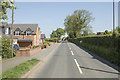
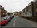
On the edge of Openwoodgate
A sunny view down the road at the edge of the suburb of Belper.
Image: © Malcolm Neal
Taken: 15 May 2018
0.08 miles
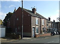
3
Whitemoor House, Over Lane, Belper
18th century stone farmhouse, Listed Grade II. The garden wall is included in the listing.
Image: © Alan Murray-Rust
Taken: 9 Jul 2017
0.10 miles
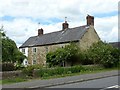
5
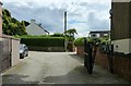
Private driveway with public footpath
Off Over Lane, Belper.
Image: © Alan Murray-Rust
Taken: 9 Jul 2017
0.13 miles
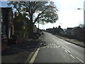
6
Over Lane, Openwoodgate
Looking towards Heage.
Image: © Stephen McKay
Taken: 18 Jun 2006
0.23 miles