IMAGES TAKEN NEAR TO
MATLOCK, DE4 9BR
Introduction
This page details the photographs taken nearby to DE4 9BR by members of the Geograph project.
The Geograph project started in 2005 with the aim of publishing, organising and preserving representative images for every square kilometre of Great Britain, Ireland and the Isle of Man.

There are currently over 7.5m images from over14,400 individuals and you can help contribute to the project by visiting https://www.geograph.org.uk
Image Map
Images are licensed for reuse under creativecommons.org/licenses/by-sa/2.0
Notes
- Clicking on the map will re-center to the selected point.
- The higher the marker number, the further away the image location is from the centre of the postcode.
Image Listing (283 Images Found)
Images are licensed for reuse under creativecommons.org/licenses/by-sa/2.0
Image
Details
Distance
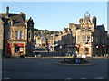
2
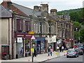
Parade of shops, Bank Street, Matlock
The flat section of the street at the foot of a long steep hill.
Image: © Andrew Hill
Taken: 19 Jun 2010
0.01 miles
4
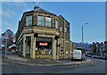
Corner of Bank Road and Lime Grove Walk, Matlock
Haydn Stanley is a long-established furniture and furnishings store serving Matlock and the surrounding area.
Image: © Neil Theasby
Taken: 16 Dec 2021
0.02 miles
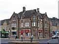
5
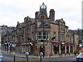
Matlock - Crown Buildings
At the junction of Bank Road with Causeway Lane. For a wider view of the bottom of Bank Road, please see Image
Image: © Dave Bevis
Taken: 2 Jan 2011
0.02 miles
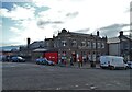
6
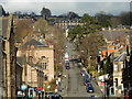
Bank Road, Matlock
Matlock is a hilly town and Bank Road seems to rise vertically from the centre.
Image: © Stephen McKay
Taken: 20 Feb 2018
0.03 miles
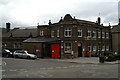
8
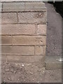
Cut bench mark on Matlock council offices
Cut bench mark on the south angle, adjacent to Bank Road. See http://www.bench-marks.org.uk/bm32272 for details.
Image: © Brian Westlake
Taken: 5 May 2011
0.03 miles
9
Matlock - The Crown
At the junction of Bank Road with Bakewell Road. Before being used as a building society office, this building was the original site of The Crown public house. For a wider view of the bottom of Bank Road, please see Image
Image: © Dave Bevis
Taken: 2 Jan 2011
0.04 miles