IMAGES TAKEN NEAR TO
Mawstone Lane, BAKEWELL, DE45 1LZ
Introduction
This page details the photographs taken nearby to Mawstone Lane, DE45 1LZ by members of the Geograph project.
The Geograph project started in 2005 with the aim of publishing, organising and preserving representative images for every square kilometre of Great Britain, Ireland and the Isle of Man.

There are currently over 7.5m images from over14,400 individuals and you can help contribute to the project by visiting https://www.geograph.org.uk
Image Map
Images are licensed for reuse under creativecommons.org/licenses/by-sa/2.0
Notes
- Clicking on the map will re-center to the selected point.
- The higher the marker number, the further away the image location is from the centre of the postcode.
Image Listing (6 Images Found)
Images are licensed for reuse under creativecommons.org/licenses/by-sa/2.0
Image
Details
Distance
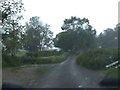
1
Overlooking Mawstone Farm and Youlgreave
Footpath descending from Harthill Moor towards the River Bradford. Mawstone Farm is in the foreground with Youlgreave (situated in SK2064 and SK2164) beyond.
Image: © Jonathan Clitheroe
Taken: 7 Aug 2011
0.02 miles
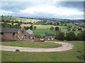
3
Peak District Hills near Youlgreave, Derbyshire
View facing east from Mawstone over rolling hills in the Derbyshire Dales, near Youlgreave.
Image: © Andrew Tryon
Taken: 28 Dec 2017
0.17 miles
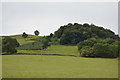
4
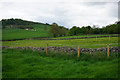
Fields below Mawstone Farm
Mawstone Farm is on the higher ground to the left. The local farms just do livestock.
Image: © Bill Boaden
Taken: 20 May 2016
0.22 miles
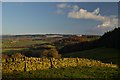
5
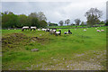
Frolicking lambs near Youlgrave
Many of the lambs, though not all, chose to congregate together in this corner of the field.
Image: © Bill Boaden
Taken: 20 May 2016
0.24 miles