IMAGES TAKEN NEAR TO
Nether Gardens/Wood Street, MATLOCK, DE4 4DW
Introduction
This page details the photographs taken nearby to Nether Gardens/Wood Street, DE4 4DW by members of the Geograph project.
The Geograph project started in 2005 with the aim of publishing, organising and preserving representative images for every square kilometre of Great Britain, Ireland and the Isle of Man.

There are currently over 7.5m images from over14,400 individuals and you can help contribute to the project by visiting https://www.geograph.org.uk
Image Map
Images are licensed for reuse under creativecommons.org/licenses/by-sa/2.0
Notes
- Clicking on the map will re-center to the selected point.
- The higher the marker number, the further away the image location is from the centre of the postcode.
Image Listing (403 Images Found)
Images are licensed for reuse under creativecommons.org/licenses/by-sa/2.0
Image
Details
Distance
1
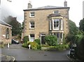
The Manor House, St Mary's Gate, Wirksworth
Image: © Derek Voller
Taken: 26 Sep 2012
0.02 miles
2
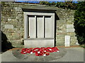
Wirksworth War Memorial
Next to the Memorial Hall
Image: © Eirian Evans
Taken: 19 Apr 2021
0.03 miles
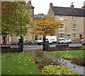
3
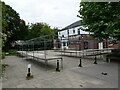
Market stalls, Wirksworth
Used for a monthly Farmers' and Craft Market.
Image: © Jonathan Thacker
Taken: 28 Aug 2023
0.04 miles
4
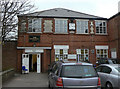
The Memorial Hall
Built in the 1930s, it has seen many uses, including being a transport café. It now houses various local organisations. Note the contemporary clock in a distinctive Art Deco style.
Image: © Alan Murray-Rust
Taken: 26 Mar 2011
0.04 miles
5
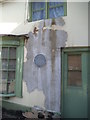
Adam Bede Plaque
Elizabeth Evans immortalised as Dinah Morris in George Eliot's Adam Bede lived here until her death in May 1849.
Image: © Gordon Griffiths
Taken: 22 Sep 2013
0.04 miles
6
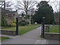
Memorial Garden
War Memorial and garden on St John's Street.
Image: © Alan Murray-Rust
Taken: 26 Mar 2011
0.04 miles
7
St John's Street, Wirksworth, Derbys
A number of Wirksworthians are not happy with a recent announcement by the Mayor, in October 2014, that consideration is being given to rebuilding the Memorial Hall and some flats on this memorial garden site. The adjoining 1930s hall - off to the left - is attached on its other side to a former cinema (now occupied by a building company). The hall started life as a country club, went on to become a cafe and currently provides office space to several local organisations and the Derbyshire County Council.
Image: © David Hallam-Jones
Taken: 18 Oct 2014
0.04 miles
8

Ecclesbourne Valley
View from Bolehill to Wirksworth and the Ecclesbourne Valley
Image: © Richard Croft
Taken: 12 Oct 2010
0.04 miles
9
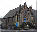
Wirksworth - Methodist Church
On St Johns Street.
Image: © Dave Bevis
Taken: 11 Jan 2011
0.05 miles
10

St.John's Street
Looking south from St. Mary's Gate. This is the main road towards Derby.
Image: © Alan Murray-Rust
Taken: 26 Mar 2011
0.05 miles