IMAGES TAKEN NEAR TO
Bentley Close, MATLOCK, DE4 3GF
Introduction
This page details the photographs taken nearby to Bentley Close, DE4 3GF by members of the Geograph project.
The Geograph project started in 2005 with the aim of publishing, organising and preserving representative images for every square kilometre of Great Britain, Ireland and the Isle of Man.

There are currently over 7.5m images from over14,400 individuals and you can help contribute to the project by visiting https://www.geograph.org.uk
Image Map
Images are licensed for reuse under creativecommons.org/licenses/by-sa/2.0
Notes
- Clicking on the map will re-center to the selected point.
- The higher the marker number, the further away the image location is from the centre of the postcode.
Image Listing (25 Images Found)
Images are licensed for reuse under creativecommons.org/licenses/by-sa/2.0
Image
Details
Distance
1
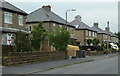
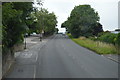
Houses on Gritstone Road
A residential street near the edge of Matlock.
Image: © Andrew Hill
Taken: 13 Jun 2012
0.07 miles
2
Gritstone Road
Residential road off Chesterfield Road.
Image: © Alan Murray-Rust
Taken: 4 Oct 2009
0.07 miles
3
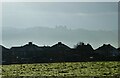
View to Riber Castle
Over the rooftops of Gritstone Road. Riber Castle can be seen through misty air as a high pressure weather system settles over England.
Image: © Neil Theasby
Taken: 16 Dec 2021
0.08 miles
4
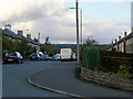
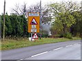
Lime Tree Hill
The notice is not to be ignored - the descent on the road from Chesterfield is continuously steep with a number of bends.
Image: © Alan Murray-Rust
Taken: 4 Oct 2009
0.08 miles
6
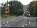
Road signs at the top of Lime Tree Hill
A very steep hill taking the A632 Chesterfield Road into Matlock
Image: © Graham Hogg
Taken: 20 Oct 2014
0.10 miles
7
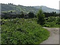
Houses at the end of Sandy Lane
The photograph was taken looking across a sharp bend on Sandy Lane. Riber Castle can be seen on the hill top beyond.
Image: © Nikki Mahadevan
Taken: 10 Sep 2009
0.11 miles
8
Sandy Lane
This footpath on the outskirts of Matlock crosses over Matlock Moor. The red dot on the track is a cyclist with a steep climb to look forward to.
Image: © Michael Patterson
Taken: 9 Jul 2006
0.13 miles
9
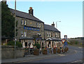
Duke of Wellington, Matlock
Stone-built pub on the corner of Chesterfield Road and Wellington Street.
Image: © Alan Murray-Rust
Taken: 4 Oct 2009
0.14 miles
10
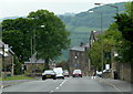
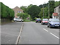
Chesterfield Road descending into Matlock
The A632 descends a long and steep hill into the town. The crossroads with Wellington Street on the right and Asker Lane on the left can be seen.
Image: © Andrew Hill
Taken: 13 Jun 2012
0.14 miles