IMAGES TAKEN NEAR TO
Hawksley Drive, MATLOCK, DE4 2HL
Introduction
This page details the photographs taken nearby to Hawksley Drive, DE4 2HL by members of the Geograph project.
The Geograph project started in 2005 with the aim of publishing, organising and preserving representative images for every square kilometre of Great Britain, Ireland and the Isle of Man.

There are currently over 7.5m images from over14,400 individuals and you can help contribute to the project by visiting https://www.geograph.org.uk
Image Map
Images are licensed for reuse under creativecommons.org/licenses/by-sa/2.0
Notes
- Clicking on the map will re-center to the selected point.
- The higher the marker number, the further away the image location is from the centre of the postcode.
Image Listing (33 Images Found)
Images are licensed for reuse under creativecommons.org/licenses/by-sa/2.0
Image
Details
Distance
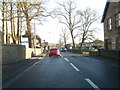
1
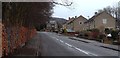
Whitworth Road, Darley Dale
Looking up the hill, residential on one side with school grounds on the other.
Image: © Andrew Hill
Taken: 15 Mar 2013
0.06 miles
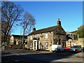
2
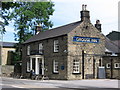
Darley Dale - Grouse Inn
On Dale Road North (A6).
Image: © Dave Bevis
Taken: 30 Jun 2010
0.07 miles
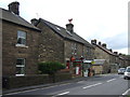
3
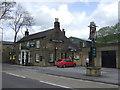
The Grouse Inn, Darley Dale
On Lime Tree Avenue (A6).
Image: © JThomas
Taken: 26 Apr 2014
0.08 miles
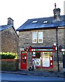
9
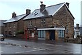
Post Office, Darley Dale
The Post Office is on the busy A6, with what looks like a former corner shop on the corner of Green Lane.
Image: © Andrew Hill
Taken: 15 Mar 2013
0.12 miles
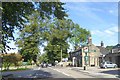
10
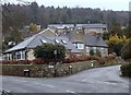
Darley Hillside
View from Whitworth Road (curving left) at the junction with Moor Lane.
Image: © Andrew Hill
Taken: 15 Mar 2013
0.13 miles