IMAGES TAKEN NEAR TO
East Bank, MATLOCK, DE4 2DS
Introduction
This page details the photographs taken nearby to East Bank, DE4 2DS by members of the Geograph project.
The Geograph project started in 2005 with the aim of publishing, organising and preserving representative images for every square kilometre of Great Britain, Ireland and the Isle of Man.

There are currently over 7.5m images from over14,400 individuals and you can help contribute to the project by visiting https://www.geograph.org.uk
Image Map
Images are licensed for reuse under creativecommons.org/licenses/by-sa/2.0
Notes
- Clicking on the map will re-center to the selected point.
- The higher the marker number, the further away the image location is from the centre of the postcode.
Image Listing (212 Images Found)
Images are licensed for reuse under creativecommons.org/licenses/by-sa/2.0
Image
Details
Distance
1
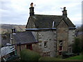
Interesting Winster house
The small windows, high chimneys, steeply pitched roof and solid stone fabric are typical of the area's defences against the elements.
The gable at the back is an interesting feature here.
I am informed that this house was the old manse.
Image: © Natasha Ceridwen de Chroustchoff
Taken: 11 Jan 2009
0.01 miles
2
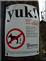
"Yuk!"
Uncompromising language used here by Derbyshire County Council - compare with a more subtle approach employed down south! Image
Image: © Natasha Ceridwen de Chroustchoff
Taken: 11 Jan 2009
0.02 miles
3
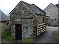
Tiny stone barn in Winster
Many of these little stone sheds can be seen in the village. They would once have been used by the 'copers' or part-time lead miners who combined working underground, perhaps in little independent teams or else for mine-owners, with small-scale farming on a patch of land. Hay, equipment or a few beasts would have been kept close to their houses and, after the week's labouring down the mineshaft, the weekends would be a chance to catch up with agricultural work. Women as well as men were actively involved in this lifestyle.
Image: © Natasha Ceridwen de Chroustchoff
Taken: 11 Jan 2009
0.02 miles
4
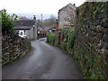
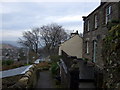
The way down to East Bank
Stone-lined lanes are the norm here: one of the routes leading down East Bank from Winster Common.
Image: © Natasha Ceridwen de Chroustchoff
Taken: 11 Jan 2009
0.02 miles
5
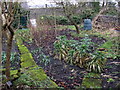
Vegetable plot in winter, in Winster
Leeks and sprouts, an apple tree and a few raspberry canes: homegrown nourishment that has probably been produced here, in small gardens such as this, for many centuries, sustaining the lead miners and their families over the course of their hard lives.
Note the very dark, almost black, soil and mossy stone-paved paths.
Image: © Natasha Ceridwen de Chroustchoff
Taken: 11 Jan 2009
0.02 miles
8
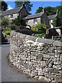
Winster, easterly view
The house on the left, Rockside, dated 1903, commands a fine view north across the village and also in this easterly direction towards Wensley and Darley Dale.
Image: © Natasha Ceridwen de Chroustchoff
Taken: 11 Jan 2009
0.03 miles
10
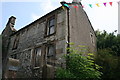
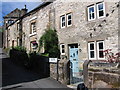
House on East Bank Winster
Late 17th century Grade II Listed house refashioned in the 18th Century. Despite the name on the gate, this house is south west of The Headlands and in the Google 2011 streetview was undergoing restoration.
Image: © Jo and Steve Turner
Taken: 28 Jun 2009
0.03 miles