
IMAGES TAKEN NEAR TO
Farnham Close, DERBY, DE3 0RE
Introduction
This page details the photographs taken nearby to Farnham Close, DE3 0RE by members of the Geograph project.
The Geograph project started in 2005 with the aim of publishing, organising and preserving representative images for every square kilometre of Great Britain, Ireland and the Isle of Man.

There are currently over 7.5m images from over14,400 individuals and you can help contribute to the project by visiting https://www.geograph.org.uk
Image Map
Images are licensed for reuse under creativecommons.org/licenses/by-sa/2.0
Notes
- Clicking on the map will re-center to the selected point.
- The higher the marker number, the further away the image location is from the centre of the postcode.
Image Listing (93 Images Found)
Images are licensed for reuse under creativecommons.org/licenses/by-sa/2.0
Image
Details
Distance
1

Ladybank Road
Between Lidgate Close and Gelnfield Crescent on Ladybank Road.
Image: © Malcolm Neal
Taken: 5 Dec 2017
0.03 miles
2

Glenfield Crescent
Glenfield Crescent connects at both ends to Ladybank Road hence its name.
Image: © Malcolm Neal
Taken: 5 Dec 2017
0.05 miles
3
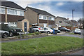
Parkstone Court
Parkstone Court is a divided road with a couple of offshoots. This sometimes confuses delivery people.
Image: © Malcolm Neal
Taken: 5 Dec 2017
0.06 miles
4

The curve of Lidgate Close
A short cul-de-sac of detached houses curves away from Weavers Green.
Image: © Malcolm Neal
Taken: 5 Dec 2017
0.06 miles
5

Weavers Green
This small square of grass is Weavers Green surrounded by short terraces of houses.
Image: © Malcolm Neal
Taken: 5 Dec 2017
0.07 miles
6
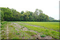
Looking at the four acre plantation
This is the penultimate centi square for SK3034 and is from a fallow field looking towards the four acre plantation which is the wood on the skyline on this dull overcast morning. There are houses to the left and beyond the wood to the right is a housing development of around 1100 planned houses.
Image: © Malcolm Neal
Taken: 4 May 2020
0.07 miles
7
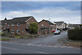
Lidgate Close
Yet another cul-de-sac off Ladybank Road. I suppose with no through traffic they are quiet.
Image: © Malcolm Neal
Taken: 5 Dec 2017
0.08 miles
8
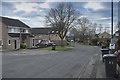
Burnham Drive
Burnham Drive one of many short streets leading to the playing fields.
Image: © Malcolm Neal
Taken: 5 Dec 2017
0.08 miles
9

The edge of Mickleover
The line of houses marks the edge of Mickleover. These houses have been there a while and are actually within the city boundary. All the other development close by is actually part of S. E. Derbyshire. This development is to the right and further beyond the line of trees seen at the edge of the picture.
Image: © Malcolm Neal
Taken: 21 Apr 2020
0.08 miles
10

Prescott Close
The other cul-de-sac end of Prescott Close.
Image: © Malcolm Neal
Taken: 5 Dec 2017
0.09 miles