IMAGES TAKEN NEAR TO
Mowbray Street, DERBY, DE24 8BL
Introduction
This page details the photographs taken nearby to Mowbray Street, DE24 8BL by members of the Geograph project.
The Geograph project started in 2005 with the aim of publishing, organising and preserving representative images for every square kilometre of Great Britain, Ireland and the Isle of Man.

There are currently over 7.5m images from over14,400 individuals and you can help contribute to the project by visiting https://www.geograph.org.uk
Image Map
Images are licensed for reuse under creativecommons.org/licenses/by-sa/2.0
Notes
- Clicking on the map will re-center to the selected point.
- The higher the marker number, the further away the image location is from the centre of the postcode.
Image Listing (17 Images Found)
Images are licensed for reuse under creativecommons.org/licenses/by-sa/2.0
Image
Details
Distance
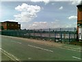
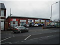
3
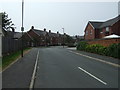
Osmaston Road (A514)
Heading north towards Derby.
Image: © JThomas
Taken: 12 Jul 2013
0.06 miles
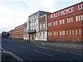
4
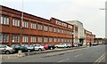
Rolls Royce works, Nightingale Road, Derby
Image: © Chris J Dixon
Taken: 22 Apr 2005
0.07 miles
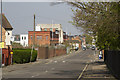
6
Derby - Rolls-Royce Factory
An alternative view (taken in 2005 when the factory was still operational) is available at Image The frontage was boarded up in 2008 and much of the works behind has been demolished since then.
Image: © Dave Bevis
Taken: 12 Nov 2010
0.08 miles
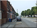
7
Nightingale Road
This road used to be the home of part of Rolls Royce Derby. All that is left now is the facade of the entrance. The rest has been demolished and awaits development, probably for housing.
Image: © Malcolm Neal
Taken: 8 Apr 2017
0.10 miles
8
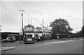
Nightingale Road turn-round on Osmaston Road ? 1967
The turn-round was provided for the use of journeys for workers at the Rolls Royce factory on Nightingale Road, then the company's principal works. Here it is being used by a pair of trolleybuses on an enthusiast tour.
The roadway still exists, providing access to a series of small industrial units on the former Ford & Weston contractors' yard.
This is one of a series of views featuring buses in the 60s, 70s, and 80s. http://www.geograph.org.uk/search.php?i=2114547&displayclass=slide
Image: © Alan Murray-Rust
Taken: 30 Jul 1967
0.10 miles
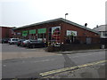
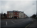
9
Former site of the Valiant Service Station
Was an ESSO petrol station with 3 service bays for car repairs
Image: © Peter Butterworth
Taken: 23 Jul 2009
0.11 miles
10
Site of the Nightingale Hotel
Junction of Nightingale Road and Osmaston Road
Image: © Peter Butterworth
Taken: 23 Jul 2009
0.12 miles