IMAGES TAKEN NEAR TO
Holt Way, DERBY, DE24 5BY
Introduction
This page details the photographs taken nearby to Holt Way, DE24 5BY by members of the Geograph project.
The Geograph project started in 2005 with the aim of publishing, organising and preserving representative images for every square kilometre of Great Britain, Ireland and the Isle of Man.

There are currently over 7.5m images from over14,400 individuals and you can help contribute to the project by visiting https://www.geograph.org.uk
Image Map
Images are licensed for reuse under creativecommons.org/licenses/by-sa/2.0
Notes
- Clicking on the map will re-center to the selected point.
- The higher the marker number, the further away the image location is from the centre of the postcode.
Image Listing (7 Images Found)
Images are licensed for reuse under creativecommons.org/licenses/by-sa/2.0
Image
Details
Distance
2
Sharp Road Bend at Thulston Fields Farm
Motorists and pedestrians alike should take care in this area. The road is busy, narrow and winding and there's no roadside path between here and Chellaston.
Image: © Jonathan Clitheroe
Taken: 1 Feb 2014
0.12 miles
3
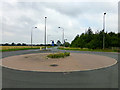
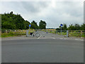
Pointless roundabout
There is no junction here for this to control apart from the road ahead and behind there's just a fenced-off lane to the right Image
Maybe it's just a traffic calming measure before the 90 degree turn a few yards to the south?
Image: © David Lally
Taken: 25 Aug 2013
0.15 miles
4
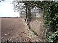
Boundary ditch and hedge
This ditch and hedge marks what is now a unitary authority boundary
Image: © Ian Calderwood
Taken: 31 Mar 2013
0.17 miles
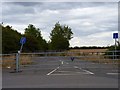
5
No through road
Even the lock does not appear to have changed in the last two years! Image
Image: © David Lally
Taken: 25 Aug 2013
0.17 miles
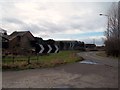
6
Abandoned stretch of Snelsmoor Lane
This section of the lane from Chellaston to Thulston was severed and abandoned when the A50 (opened in 1997) was built. The hedge in the middle distance on the right of the picture marks the line of the A50.
Image: © Richard Green
Taken: 21 Aug 2011
0.19 miles
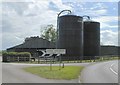
7
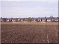
Hardhurst Farm
This blob of uncultivated land in the middle of a field is all that remains of Hardhurst Farm, which was demolished some time in the late 1960s or early 1970s.
Image: © Ian Calderwood
Taken: 31 Mar 2013
0.22 miles