IMAGES TAKEN NEAR TO
Tedworth Avenue, DERBY, DE24 3BS
Introduction
This page details the photographs taken nearby to Tedworth Avenue, DE24 3BS by members of the Geograph project.
The Geograph project started in 2005 with the aim of publishing, organising and preserving representative images for every square kilometre of Great Britain, Ireland and the Isle of Man.

There are currently over 7.5m images from over14,400 individuals and you can help contribute to the project by visiting https://www.geograph.org.uk
Image Map
Images are licensed for reuse under creativecommons.org/licenses/by-sa/2.0
Notes
- Clicking on the map will re-center to the selected point.
- The higher the marker number, the further away the image location is from the centre of the postcode.
Image Listing (8 Images Found)
Images are licensed for reuse under creativecommons.org/licenses/by-sa/2.0
Image
Details
Distance
1

Wragley Way, Stenson Fields
Wragley Way runs along the southern boundary of Derby's urban area. To the south is open countryside.
Image: © Nikki Mahadevan
Taken: 6 Feb 2007
0.06 miles
2
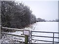
Civil parish boundary hedges
The hedge on the left marks the boundary between Twyford and Stenson CP and Stenson Fields CP. The hedge in the background marks the boundary with Barrow upon Trent CP. Despite the warning notice, the field is popular with dog walkers.
Image: © Ian Calderwood
Taken: 21 Jan 2013
0.18 miles
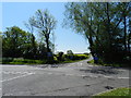
3
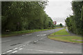
Wragley Way
This view looks back towards Derby's suburb of Littleover via another right angled road junction.
Image: © Malcolm Neal
Taken: 30 Jun 2017
0.21 miles
6
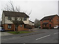
Tregony Way
1990s houses in Stenson Fields.
Image: © Burgess Von Thunen
Taken: 27 Feb 2013
0.23 miles
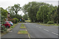
7
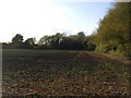
Unsuitable for through traffic
The road ahead crosses the A50.Farmland ahead with oil seed rape.
Image: © Peter Barr
Taken: 25 May 2012
0.24 miles
8
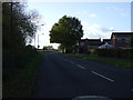
Arleston Lane
This is the very edge of Sinfin and hence Derby.
Image: © Malcolm Neal
Taken: 30 Jun 2017
0.25 miles