IMAGES TAKEN NEAR TO
Cambridge Street, DERBY, DE23 8HG
Introduction
This page details the photographs taken nearby to Cambridge Street, DE23 8HG by members of the Geograph project.
The Geograph project started in 2005 with the aim of publishing, organising and preserving representative images for every square kilometre of Great Britain, Ireland and the Isle of Man.

There are currently over 7.5m images from over14,400 individuals and you can help contribute to the project by visiting https://www.geograph.org.uk
Image Map
Images are licensed for reuse under creativecommons.org/licenses/by-sa/2.0
Notes
- Clicking on the map will re-center to the selected point.
- The higher the marker number, the further away the image location is from the centre of the postcode.
Image Listing (30 Images Found)
Images are licensed for reuse under creativecommons.org/licenses/by-sa/2.0
Image
Details
Distance
1
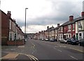
Dairy House Road in Rose Hill
Pictured here at its junction with Catherine Street on the left of picture.
Image: © Jonathan Clitheroe
Taken: 24 Aug 2013
0.11 miles
2
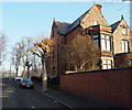
Derby - Arboretum vicinity
Although the address of this property is No.86, Rose Hill Street the main pedestrian entrance appears to be here on Wilfred Street. This Jacobean-style house (c.1822) is the second property to have been built on this site and this one is thought to have been designed by Joseph Strutt, the Arboretum benefactor. The west gable is in Flemish style and the south gable sports a large sundial set into a stone surround. The far end elevation overlooks Rose Hill Recreation Ground, that borders the Arboretum. In Rose Hill Street there is a large yard, perhaps used for coaches and stabling in the past. As "Rosehill House" it may now be being used as a residential care facility?
Image: © David Hallam-Jones
Taken: 13 Dec 2012
0.14 miles
3
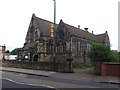
St Thomas Church
Anglican church in central Derby.
Image: © Graham Hogg
Taken: 18 Aug 2012
0.15 miles
4
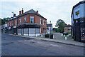
Roe Walk
Some 50+ ears ago this was Roe Street but all of the terraced houses have been demolished, and the area has undergone some regeneration. This all happened over 40 years ago and many of the shops around here now seem shut up.
Image: © Malcolm Neal
Taken: 16 Oct 2021
0.16 miles
5
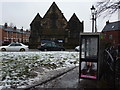
Half an invisible woman
Remains of a film poster, in phone box outside Pear Tree Library, in Derby. And St. Thomas Church.
Image: © Peter Barr
Taken: 6 Feb 2012
0.16 miles
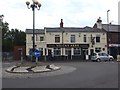
7
A pub no more
Just behind the road closed sign is a small green area. This used to be the site of the public house "The Sir Brian Robertson". I lived very close to here some 50+ years ago and the area is now very different.
Image: © Malcolm Neal
Taken: 16 Oct 2021
0.17 miles
8

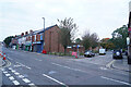
Terraced houses in Crewe Street, Derby
The scene is typical of the many streets of terraced houses in the Pear Tree area of Derby
Image: © Philip Grimshaw
Taken: 12 Sep 2005
0.17 miles
9
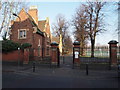
Derby - Arboretum
The Rose Hill Street entrance/exit. Behind the lodge the former Joseph Strutt Bowling Club can be seen - "the oldest crown bowling green in England" - the club house of which is now occupied by The Butterfly Project (see www.butterflyproject.co.uk).
Image: © David Hallam-Jones
Taken: 13 Dec 2012
0.17 miles
10
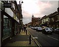
Normanton Road in Normanton in Derby
A great range of shops and culture on Normanton Road. As usual the street is full of cars.
Image: © Victuallers
Taken: 31 Aug 2009
0.17 miles