IMAGES TAKEN NEAR TO
Princes Drive, DERBY, DE23 6DX
Introduction
This page details the photographs taken nearby to Princes Drive, DE23 6DX by members of the Geograph project.
The Geograph project started in 2005 with the aim of publishing, organising and preserving representative images for every square kilometre of Great Britain, Ireland and the Isle of Man.

There are currently over 7.5m images from over14,400 individuals and you can help contribute to the project by visiting https://www.geograph.org.uk
Image Map
Images are licensed for reuse under creativecommons.org/licenses/by-sa/2.0
Notes
- Clicking on the map will re-center to the selected point.
- The higher the marker number, the further away the image location is from the centre of the postcode.
Image Listing (69 Images Found)
Images are licensed for reuse under creativecommons.org/licenses/by-sa/2.0
Image
Details
Distance
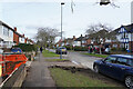
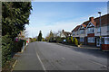
1
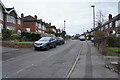
Princes Drive
Princes Drive is a residential street of mainly semi-detached houses of some age.
Image: © Malcolm Neal
Taken: 5 Mar 2021
0.00 miles
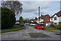
2
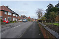
Princes Drive
Quite a number of the houses on Princes Drive appear to have been given a new roof.
Image: © Malcolm Neal
Taken: 17 Feb 2021
0.03 miles
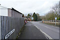
3
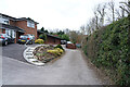
Owlers Lane
This is the very end of Owlers Lane with the hospital to the right of the hedge separated by the hedge and a sturdy fence.
Image: © Malcolm Neal
Taken: 5 Mar 2021
0.06 miles
4
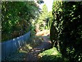
Owlers Lane
Formerly a main route out of Littleover. Now just a footpath squeezed between the houses and the hospital.
Image: © Ian Calderwood
Taken: 29 Sep 2018
0.06 miles
5
Crich Avenue
Crich Avenue is a well established housing street in Littleover.
Image: © Malcolm Neal
Taken: 17 Feb 2021
0.06 miles
6
Queens Drive
Queens Drive is a fairly steep hill with detached and some semi-detached houses on both sides.
Image: © Malcolm Neal
Taken: 5 Mar 2021
0.08 miles
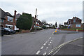
7
Princes Drive
The signs on both sides of the road warn about permit parking only between 8am and 6pm. The road is close to Derby's major hospital and parking used to be a big problem.
Image: © Malcolm Neal
Taken: 17 Feb 2021
0.08 miles
8
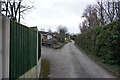
Owlers Lane
A narrow road leading to houses just on the left hand side. The reason for this is that the Royal Derby Hospital is beyond the hedge and fence on the right of the lane.
Image: © Malcolm Neal
Taken: 5 Mar 2021
0.08 miles
9
Lawn Heads Avenue
Looking at Crich Circle with its tall conifer and other trees which is at the end of Lawn Heads Avenue. Crich Circle connects Lawn Heads Avenue, Crich Avenue and Queens Drive around a small but well stocked island.
Image: © Malcolm Neal
Taken: 13 Feb 2021
0.10 miles
10
Scarsdale Avenue
This is the left hand branch of the cul-de-sac.
Image: © Malcolm Neal
Taken: 17 Feb 2021
0.11 miles