
IMAGES TAKEN NEAR TO
Mackworth Avenue, DERBY, DE23 3WB
Introduction
This page details the photographs taken nearby to Mackworth Avenue, DE23 3WB by members of the Geograph project.
The Geograph project started in 2005 with the aim of publishing, organising and preserving representative images for every square kilometre of Great Britain, Ireland and the Isle of Man.

There are currently over 7.5m images from over14,400 individuals and you can help contribute to the project by visiting https://www.geograph.org.uk
Image Map
Images are licensed for reuse under creativecommons.org/licenses/by-sa/2.0
Notes
- Clicking on the map will re-center to the selected point.
- The higher the marker number, the further away the image location is from the centre of the postcode.
Image Listing (2 Images Found)
Images are licensed for reuse under creativecommons.org/licenses/by-sa/2.0
Image
Details
Distance
1

Across the Trent Valley on a spring evening
A view from the car park of the Littleover Lodge Hotel taken at 5.30 on an in-and-out March day. The five cooling towers are all that remains of Willington Power Station, closed in the 1990s. On the skyline are the hills of South Derbyshire, beyond Repton and Milton.
Image: © John Sutton
Taken: 12 Mar 2013
0.11 miles
2
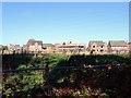
Field fenced off for development
The new houses of the Highfields development are advancing towards Bakeacre Lane, although it looks like this corner of the field might be left as green space with a balancing pond.
Image: © Ian Calderwood
Taken: 13 Nov 2018
0.24 miles