IMAGES TAKEN NEAR TO
Hollybrook Way, DERBY, DE23 3TZ
Introduction
This page details the photographs taken nearby to Hollybrook Way, DE23 3TZ by members of the Geograph project.
The Geograph project started in 2005 with the aim of publishing, organising and preserving representative images for every square kilometre of Great Britain, Ireland and the Isle of Man.

There are currently over 7.5m images from over14,400 individuals and you can help contribute to the project by visiting https://www.geograph.org.uk
Image Map
Images are licensed for reuse under creativecommons.org/licenses/by-sa/2.0
Notes
- Clicking on the map will re-center to the selected point.
- The higher the marker number, the further away the image location is from the centre of the postcode.
Image Listing (34 Images Found)
Images are licensed for reuse under creativecommons.org/licenses/by-sa/2.0
Image
Details
Distance
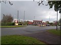
1
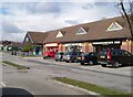
Shops at Heatherton Village
This row of shops serves a large new housing estate. There is currently a small Co-op, a chemist, a beauty salon, a chippy and an Indian restaurant.
Image: © Ray Folwell
Taken: 27 Mar 2008
0.00 miles
2
Heatherton Shops
This small line of shops serves the fairly new housing estate, Heatherton, on the edge of Derby. However there are plans to extend the housing of Derby beyond this area though they are not yet completely confirmed.
Image: © Malcolm Neal
Taken: 15 Mar 2017
0.02 miles
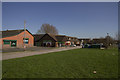
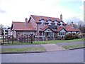
4
A care home
To the right is Derby Heights Care Home, to the left some of the buildings of the Nuffield Hospital.
Image: © Malcolm Neal
Taken: 2 Mar 2021
0.04 miles
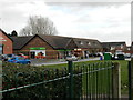
5
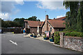
The rear of the Hollybrook Tavern
This is an Ember Inn that does more food than drink at a guess. It is relatively modern being not much more than 30 years old.
Image: © Malcolm Neal
Taken: 16 Sep 2021
0.06 miles
6
The Hollybrook
The real name of the local brook is "Hell Brook". The area known as "Heatherton Village", including the pub, was developed in the 1990s.
Image: © Ian Calderwood
Taken: 13 Mar 2013
0.06 miles
7
The Hollybrook Public House
Situated by a roundabout at the junction of Rykneld Road and Hollybrook Way.
Image: © Jonathan Clitheroe
Taken: 25 Apr 2015
0.06 miles
8
The Hollybrook Tavern
The public house serving the newish development of Heatherton on the edge of Derby. The public house is more of an eating establishment rather than a drinking house.
Image: © Malcolm Neal
Taken: 15 Mar 2017
0.07 miles
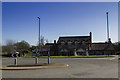
9
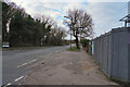
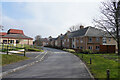
Rykneld Road
Looking along Rykneld Road away from Derby towards the eventual junction with the A38. The fence to the right surrounds the redevelopment of the old Co-op shop site.
Image: © Malcolm Neal
Taken: 7 Feb 2021
0.08 miles
10
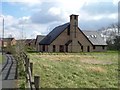
Haven Christian Centre, Littleover
This modern church is a joint venture between the Anglicans, Baptists, Methodists and United Reformed Church.
Image: © Ray Folwell
Taken: 27 Mar 2008
0.09 miles