IMAGES TAKEN NEAR TO
Quarndon, DERBY, DE22 5LF
Introduction
This page details the photographs taken nearby to DE22 5LF by members of the Geograph project.
The Geograph project started in 2005 with the aim of publishing, organising and preserving representative images for every square kilometre of Great Britain, Ireland and the Isle of Man.

There are currently over 7.5m images from over14,400 individuals and you can help contribute to the project by visiting https://www.geograph.org.uk
Image Map
Images are licensed for reuse under creativecommons.org/licenses/by-sa/2.0
Notes
- Clicking on the map will re-center to the selected point.
- The higher the marker number, the further away the image location is from the centre of the postcode.
Image Listing (6 Images Found)
Images are licensed for reuse under creativecommons.org/licenses/by-sa/2.0
Image
Details
Distance
1
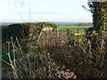
Public footpath to Quarndon
According to the leaning signpost, Quarndon is 2 miles away.
Image: © Ian Calderwood
Taken: 14 Dec 2016
0.06 miles
2
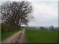
Track and Footpath Towards Champion Farm
Pictured on a slightly murky Easter Sunday afternoon.
Image: © Jonathan Clitheroe
Taken: 20 Apr 2014
0.13 miles
4

Cumberhills Road
Cumberhills Road runs from Duffield through open countryside, where there is good arable and grazing land.
Image: © Malcolm Neal
Taken: 5 Oct 2017
0.18 miles
5
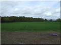
Farmland towards Ireton Rough
Off Cumberhills Road.
Image: © JThomas
Taken: 26 Apr 2014
0.21 miles
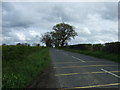
6
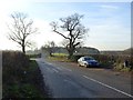
Lay-by at the crossroads on Cumberhills Road
Image: © Ian Calderwood
Taken: 14 Dec 2016
0.24 miles