IMAGES TAKEN NEAR TO
Fulham Road, DERBY, DE22 4GD
Introduction
This page details the photographs taken nearby to Fulham Road, DE22 4GD by members of the Geograph project.
The Geograph project started in 2005 with the aim of publishing, organising and preserving representative images for every square kilometre of Great Britain, Ireland and the Isle of Man.

There are currently over 7.5m images from over14,400 individuals and you can help contribute to the project by visiting https://www.geograph.org.uk
Image Map
Images are licensed for reuse under creativecommons.org/licenses/by-sa/2.0
Notes
- Clicking on the map will re-center to the selected point.
- The higher the marker number, the further away the image location is from the centre of the postcode.
Image Listing (16 Images Found)
Images are licensed for reuse under creativecommons.org/licenses/by-sa/2.0
Image
Details
Distance
1
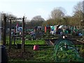
Mackworth Allotment and Community Gardens
Mackworth’s community allotments were created thanks to Community Spaces and Derby Homes funding and were officially opened by the Mayor of the City of Derby, Councillor Les Allen, on Friday 30 March 2012.
There were allotments here previously but these had been abandoned and become overgrown so that the site had to be cleared and laid out from scratch.
Image: © Ian Calderwood
Taken: 22 Dec 2017
0.16 miles
2
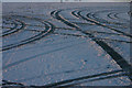
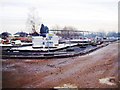
Tracks in the snow
Tracks in the snow in a carpark that no longer exists. The Mackworth College that used to be here has been redeveloped for housing since the picture was taken in 2004.
Image: © Malcolm Neal
Taken: 28 Jan 2004
0.17 miles
3
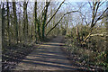
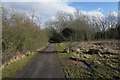
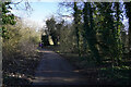
On the footpath to Mackworth
Looking back along the path to a distant Mickleover. The railway cutting is to the right of the path in this view.
Image: © Malcolm Neal
Taken: 15 Feb 2021
0.17 miles
4
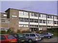
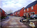
A Block Mackworth College
The former A Block at Mackworth FE College. When the college merged with Wilmorton College to become Derby College this site (one of two) of Mackworth College was not needed and sold for housing which now occupies the site.
Image: © Malcolm Neal
Taken: 3 Apr 1998
0.18 miles
5
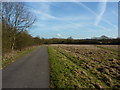
On the footpath to Mackworth
The fields are still water logged as you can tell by the puddles to the right of the path.
Image: © Malcolm Neal
Taken: 15 Feb 2021
0.18 miles
7
On the footpath to Mackworth
Looking away from Mackworth in the direction we have walked. We are almost at our turn round point as the path did not go quite where we thought to do a circular walk.
Image: © Malcolm Neal
Taken: 15 Feb 2021
0.19 miles
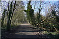
8
On the footpath to Mackworth
The path turns to the left just beyond the people and then joins Greenwich Drive South. Beyond the left hedge are a series of allotment gardens.
Image: © Malcolm Neal
Taken: 15 Feb 2021
0.19 miles
9
Cycle route towards Derby
Former railway line is in a cutting on the left.
Image: © Peter Barr
Taken: 8 Feb 2011
0.21 miles